
My Nuvi 765t is about 12 years old now. I laid a tiny bead of silicone around the edge of the display years ago and give it a tiny spray of ACF50 now and then. It was a $90 ebay deal. Still works perfectly although the screen is badly worn. It's on a ram mount.


You are using an out of date browser. It may not display this or other websites correctly.
You should upgrade or use an alternative browser.
You should upgrade or use an alternative browser.
What GPS & mount do you run or are you a phone or paper map rider?
- Thread starter Clutt-225
- Start date
I can't stand any sort of clutter on the bars; no phones, no cup holders, no ash trays, no ugly Ram mounts, no kitchen sinks.
I've always preferred paper maps, stubbornly refusing GPS, until my wife gave one as a gift, a Garmin 396.
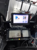
I chose a minimalist installation, fabbing brackets and a nav bar above the main display. The GPS is mounted on a Moto Pumps bracket, GPS Mount — MotoPumps - The Best 12v Inflators on the Planet, $49.99USD (ten bucks off for members of that big ADV site).


Sure, the GPS is beneficial, particularly for navigating cities, but it's not enough. The GPS doesn't give the big picture; I'm certain I'm missing some good stuff. The best solution for me is GPS and paper maps.
Maps work with my tank bag, but I don't always ride with the tank bag. The next project is to figure a way to strap a map on its own to the tank. Any suggestions for a simple, waterproof pouch?
I've always preferred paper maps, stubbornly refusing GPS, until my wife gave one as a gift, a Garmin 396.
I chose a minimalist installation, fabbing brackets and a nav bar above the main display. The GPS is mounted on a Moto Pumps bracket, GPS Mount — MotoPumps - The Best 12v Inflators on the Planet, $49.99USD (ten bucks off for members of that big ADV site).
Sure, the GPS is beneficial, particularly for navigating cities, but it's not enough. The GPS doesn't give the big picture; I'm certain I'm missing some good stuff. The best solution for me is GPS and paper maps.
Maps work with my tank bag, but I don't always ride with the tank bag. The next project is to figure a way to strap a map on its own to the tank. Any suggestions for a simple, waterproof pouch?

Should be adaptible Overboard Waterproof Map case - Medium (A4) | eBay
My dash and tank bag are cluttered with things I need to enjoy the ride without dismounting. My X mount folds out of the way as rarely need visual nav over voice nav and cup/waterbottle holder is essential in the tropics. Camera gear, power bank, gate opener and meds in the tank bag ...I power the nav from the power bank rather than a USB wired set up.

Last edited:
Same here. My GPS was included with my BMW otherwise I'd be using google maps on my phone that stays in my pocket. Now that I'm used to having it I'd not go without one installed on a bike (if could be done cleanly, and preferably my next bike will have it integrated into the TFT dash).I can't stand any sort of clutter on the bars; no phones, no cup holders, no ash trays, no ugly Ram mounts, no kitchen sinks.
I've always preferred paper maps, stubbornly refusing GPS, until my wife gave one as a gift, a Garmin 396.
Hack
Well-known member
My Nuvi 765t is about 12 years old now. I laid a tiny bead of silicone around the edge of the display years ago
Similar story...
Before I bought the 396 I ran with a Garmin Nuvi 250 I bought in 2009.
Still nothing wrong with it.
I can't stand any sort of clutter on the bars; no phones, no cup holders, no ash trays, no ugly Ram mounts, no kitchen sinks.
I've always preferred paper maps, stubbornly refusing GPS, until my wife gave one as a gift, a Garmin 396.
I chose a minimalist installation, fabbing brackets and a nav bar above the main display. The GPS is mounted on a Moto Pumps bracket, GPS Mount — MotoPumps - The Best 12v Inflators on the Planet, $49.99USD (ten bucks off for members of that big ADV site).
View attachment 51727
View attachment 51728
Sure, the GPS is beneficial, particularly for navigating cities, but it's not enough. The GPS doesn't give the big picture; I'm certain I'm missing some good stuff. The best solution for me is GPS and paper maps.
Maps work with my tank bag, but I don't always ride with the tank bag. The next project is to figure a way to strap a map on its own to the tank. Any suggestions for a simple, waterproof pouch?
Agreed. It's much easier to see a larger scale on regional paper maps. Usually I will plan routes using a paper map and then transcribe it into my GPS so I don't accidentally miss any poorly labelled roads.
Mad Mike
Well-known member
I have one of those. During a romp down DeepBay Rd last weekend the mount sacrificed my iPhone.I've been using the ram mount for years. I like my GPS in portrait mode. I feel like I can see further up ahead but I have to deal with the wet charging port from time to time. Also have to deal with it rotating sometimes.

Hack
Well-known member
I initially set up a GPS on my bike in preparation for my first ride out to BC...
I thought it would be handy for directions, but really... All you gotta do is follow the road signs.
I still like having the GPS if for nothing else but knowing how far up the road the next gas stn. is or finding a hotel in an unfamiliar town.
With my FJR one other big plus with having the GPS on is knowing how fast you're actually going...
The speedo on the FJR are notoriously out of sync with reality.... Lol
Max527
Well-known member
Been using an old LG Android phone with current traffic data from Google Maps tethered to my main phone in tank bag. This way I don't worry if it falls or gets damaged with bumps. Replacement cost? $50-$150. Backup phones can be found on Kijiji or FB.
Cheaper than any other GPS machine made by Garmin that isn't close to what Google maps offers.

Cheaper than any other GPS machine made by Garmin that isn't close to what Google maps offers.
Cheaper than any other GPS machine made by Garmin that isn't close to what Google maps offers.
Contentious point, I find a dedicated gps like Garmin does have some definite advantages to google maps or any cell phone app
Max527
Well-known member
Does garmin connect to the internet? Does it have real-time speed traps or traffic jams or jams? Can garmin direct you to any address you previously searched for on your phone by simply bringing up your history on Google maps?Contentious point, I find a dedicated gps like Garmin does have some definite advantages to google maps or any cell phone app
I'm sure garmin has some cool off-roading features but nothing can ever top Google maps because it's changing all the time for the better. Just my opinion.
sburns
Well-known member
I use a Garmin Nuvi car GPS with a RAM mount. The mount is a cradle type which matches the size of the GPS.
For long trips I also use paper notes attached to the tank.
But for day to day the GPS is mostly used to see what's ahead, to spot interesting forest areas, parks, water, and of course the clock.
Besides long trips I never (or rarely) plan routes, just go.
For long trips I also use paper notes attached to the tank.
But for day to day the GPS is mostly used to see what's ahead, to spot interesting forest areas, parks, water, and of course the clock.
Besides long trips I never (or rarely) plan routes, just go.
Does garmin connect to the internet? Does it have real-time speed traps or traffic jams or jams? Can garmin direct you to any address you previously searched for on your phone by simply bringing up your history on Google maps?
I'm sure garmin has some cool off-roading features but nothing can ever top Google maps because it's changing all the time for the better. Just my opinion.
I didn't say it was better in every way, but it definitely has some advantages. Below is true for Zumo 595, but I'm sure is applicable to other models as well
- Able to use it with gloves. The UI is glove friendly, everything can be done easily without removing gloves and while riding if needed
- Able to easily add stops and modify route on the go. Detour by road, allows you to easily bypass a specific road along the route which is crazy useful
- Realtime traffic, not as good as google, but surprisingly decent
- Amount of data available on screen beyond the usual, mine shows compass, map scale, elevation, temperature (compass and scale is indispensable to me). Also has a neat feature that shows your elevation along your route, super helpful when riding in mountains
- Weather, gives you weather along the route, as well as radar map overlaid onto route (see my pic above)
- Media player, can browse Spotify and phone music app. Browser is crappy, but it's there and it works
- Built in TPMS with accessory sensors
Yes you can accomplish the same with different apps on your phone, but can't switch while riding and with gloves. Garmin puts it all in one package.
sburns
Well-known member
I believe this is why some use a older phone device (second phone) as GPS, for same reasons.If the phone falls off, i have lost my means of communication with home.
If the gps falls off, I've lost an easily replaced device.
Max527
Well-known member
Fair enough. I was unaware of all those features. I guess I'm so used to google maps since 2009 that I can't abandon it lolI didn't say it was better in every way, but it definitely has some advantages. Below is true for Zumo 595, but I'm sure is applicable to other models as well
- Able to use it with gloves. The UI is glove friendly, everything can be done easily without removing gloves and while riding if needed
- Able to easily add stops and modify route on the go. Detour by road, allows you to easily bypass a specific road along the route which is crazy useful
- Realtime traffic, not as good as google, but surprisingly decent
- Amount of data available on screen beyond the usual, mine shows compass, map scale, elevation, temperature (compass and scale is indispensable to me). Also has a neat feature that shows your elevation along your route, super helpful when riding in mountains
- Weather, gives you weather along the route, as well as radar map overlaid onto route (see my pic above)
- Media player, can browse Spotify and phone music app. Browser is crappy, but it's there and it works
- Built in TPMS with accessory sensors
Yes you can accomplish the same with different apps on your phone, but can't switch while riding and with gloves. Garmin puts it all in one package.
There can be a bunch more reasons too.Fair enough. I was unaware of all those features. I guess I'm so used to google maps since 2009 that I can't abandon it lol
One thing I also like about the Garmin is that when I’m approaching a school zone it sends off a mild, but audible alarm and the screen shows it too. This is super helpful when travelling in unfamiliar areas.
I’m not certain but I also think that google maps has a limit of about 10 waypoints on a route. If I want to take a short trip or a simple route that’s fine, but on a long twisty ride or while travelling, I often exhaust the google maps threshold by lunch time. However I think the prevalence of 3rd party routing apps are becoming much better and they might even be better than google maps is now (like MyRoute-app).
Lastly, I’ve had my bike mount fail and my Garmin go flying off my bike at 80km/hr down the road. I could see the gps
bouncing along the road in my mirrors and I freaked out. I doubled back and the unit had some scrapes, but was still totally fine! My phone would have been destroyed on the first bounce.
I do like using my phone sometimes (commuting or local rides in traffic) and I do like using paper maps sometimes (to see the big picture view of a longer route), but the dedicated Garmin is a better overall setup for exactly what I’m looking for. YMMV.
Last edited:
D
Deleted member 54626
Guest
I agree. Best feature is how it displays heavy/stopped traffic and routes you onto the fastest route to your destination, updating the route constantly as needed due to changing traffic conditions. I assume Mama Google monitors other people's locations and speeds but what we don't know is if they need to be running Maps or not to share the data live. I find it indispensable in my daily travels. But every once in awhile, it gets super-wonky for a day or 2....ever notice that?Does garmin connect to the internet? Does it have real-time speed traps or traffic jams or jams? Can garmin direct you to any address you previously searched for on your phone by simply bringing up your history on Google maps?
I'm sure garmin has some cool off-roading features but nothing can ever top Google maps because it's changing all the time for the better. Just my opinion.
Roadghost
Well-known member
My KTM came with a rough-in for a Garmin. I'm running the Garmin Zumo XT. Haven't lost it yet.


