Cell signal in the Highlands/Barrie's Bay area? | GTAMotorcycle.com

Cell signal in the Highlands/Barrie's Bay area?

Relax

Well-known member
I'm planning on doing these two routes posted by @shanekingsley but wondering if there is cell signal along the majority of the route so I can use my phone instead of a dedicated GPS:

Re: The best roads/routes in Ontario/Quebec/U.S.

Peterborough north route:
Here's a route including all the roads north of Peterborough with a run around Haliburton Lake Rd and Harburn Rd, because they are so awesome. This route can be done in around 10 hours from the GTA.

Barry's Bay area route: this is a shorter route including all the Barry's Bay roads mentioned above. There are many other smaller back roads in this area worth exploring, and/or you can take this route and link it up with some of the roads south of Algonquin Park (above) or south of Calabogie (below)


EDIT:

I remapped the first 8 hour leg (without stops) in Google Maps with specific waypoints so the route doesn't change when adding a different starting point or changing routing options like avoid tolls or highways. I used More than 10 - How to add more than 10 destinations in Google Maps to append more than 10 waypoints to a single route:


Here's the second leg (4 hours without stops) from Maynooth back to Mississauga:


And finally the entire round trip route so you can slice and dice as you see fit:

 
Last edited:
I had no issues wherever we stopped. The lowest signal was right by the streetcar.

Outside of that wherever we want I had 75-100% signal on KOODO.
 
Your phone has a GPS unit in it, doesn't require data to get position. The map app might need data to download the area if it's not already though.
 
My chatr lost cell around hwy 41 and hwy71/65 (Griffin On)
but was ok around Calabogie

Get a free motorcycle map for the area at
 
Your phone has a GPS unit in it, doesn't require data to get position. The map app might need data to download the area if it's not already though.
Yes, but I use Calimoto for navigation. With Google Maps, I can get offline maps, but the navigation sucks with waypoints - you have to acknowledge every waypoint, and tapping with my gloves on doesn't always work. Any alternative recommendations?
 
I think with the Peterborough route you should be ok. I think that if you lost cell signal it would only be momentarily but it would come back shortly and you are always very close to main roads anyways. So as long as you generally know your route a few km in advance you should be good.

For the Barry’s Bay Area, you might lose your cell signal a bit more often, but I still think you should be ok for the most part - especially if you already have a decent sense of direction. Anytime I have done these roads and stopped for a break in the middle of nowhere, I have never had an issue with cell service. I’m with Telus for whatever that’s worth.

A fail safe option would be: prior to going for your ride, to zoom into your route at various points on your phone and take screenshots that are saved to images. Then if you did get lost, you have those as a reference to figure out what to do.

When I started riding up in those areas, I would bring my paper backroads map book and also write out turn by turn directions and keep those in the clear cover of my tank bag
Sometimes I would also print up a google map of my route, or the Big Map in my signature (laminated) and keep that in my tank bag. That’s even how I did my first trips to Deals Gap and Barber Museum, since my GPS failed so often back then.
 
Last edited:
I think with the Peterborough route you should be ok. I think that if you lost cell signal it would only be momentarily but it would come back shortly and you are always very close to main roads anyways. So as long as you generally know your route a few km in advance you should be good.

For the Barry’s Bay Area, you might lose your cell signal a bit more often, but I still think you should be ok for the most part - especially if you already have a decent sense of direction. Anytime I have done these roads and stopped for a break in the middle of nowhere, I have never had an issue with cell service. I’m with Telus for whatever that’s worth.

A fail safe option would be: prior to knowing for your ride, to zoom into your route at various points on your phone and take screenshots that are saved to images. Then if you did get lost, you have those as a reference to figure your what to do.

When I started riding up in those areas, I would bring my paper backroads map book and also write out turn by turn directions.
Sometimes I would also print up a google map of my route, or the Big Map in my signature (laminated) and keep that in my tank bag. That’s even how I did my first trips to Deals Gap and Barber Museum, since my GPS failed so often back then.

Thanks. I'm not worried about getting lost, just wasting time and missing the twisties. I tried to do your route a couple weeks ago and was having problems with my export of your Google Maps to GPX and importing to Calimoto (which I think I've since fixed). I ended up on a lot of straight roads and making lots of stops to turn around and get back on track. If I was alone, no problem, but a friend of mine was with me and impatient, and every time we stopped he took all his gear off to cool off, which wasted so much time we only made it 1/4 of the way before we had to turn around for home. This time we're leaving at the crack of dawn and staying over in the area, so at least that won't be a problem again.
 
10 mins here, 10 mins there adds up. Before you know it, it's dark - especially now.
But a quick off the bike stretch does wonders!
 
Thanks. I'm not worried about getting lost, just wasting time and missing the twisties. I tried to do your route a couple weeks ago and was having problems with my export of your Google Maps to GPX and importing to Calimoto (which I think I've since fixed). I ended up on a lot of straight roads and making lots of stops to turn around and get back on track. If I was alone, no problem, but a friend of mine was with me and impatient, and every time we stopped he took all his gear off to cool off, which wasted so much time we only made it 1/4 of the way before we had to turn around for home. This time we're leaving at the crack of dawn and staying over in the area, so at least that won't be a problem again.
Great. If you think you’ve fixed the mapping issue then you should be fine. As you probably know, the cell issues typically happen at weird elevation points or more remote sections of the route, but on these routes you are always a road or two away from a main area. If you even had a list of the roads you wanted to take typed in order on your phone, then that could be a simple back up.

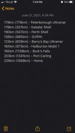
When I do group rides and I’m also thinking about gas stops, then I also have a note saved in my phone that lists the locations and distances between gas stops. It’s super helpful while on a longer ride to have this quick reference of what to expect. Something like:
6A800CA4-1607-403B-8E7F-0D1198EDE5F9.jpeg
 
Long ago, I was in a group reading a sheet map while riding up hwy 11. Not a great plan. Paper maps in the wind don't last long.
Yeah I'm happy to have one for emergencies but casually checking a paper map on a bike sucks. Plus once you pull that out you are almost guaranteed to have a cager stop and ask if you're lost before you're done reading it
 
As a telecom engineer I have hard time to believe that this thing actually does anything.
Well it should help if it has line of sight (and is properly designed). Basically turning crap signal to ok signal by climbing a hill and focusing the power in one direction. Once you get beyond that, I doubt the one shown can turn a zero into something good (although maybe a tall enough tower could make it happen).
 
No need to worry about reading a paper map and folding it in the wind; It's spiral bound:

51Lrlv+ZMoL._SX390_BO1,204,203,200_.jpg

 
No need to worry about reading a paper map and folding it in the wind; It's spiral bound:

51Lrlv+ZMoL._SX390_BO1,204,203,200_.jpg

Absolutely useable but I think it's ok to admit that while navigation without a GPS/smartphone is still certainly possible, it definitely improved navigation to the point where you will miss it if it's gone
 
Absolutely useable but I think it's ok to admit that while navigation without a GPS/smartphone is still certainly possible, it definitely improved navigation to the point where you will miss it if it's gone

For sure it makes things easier. I always use my GPS on rides. I always make sure I have an analog backup, just in case.
 

Back
Top Bottom