My personal experience is no wildlife to worry about on the 400.Yes, that's the plan. Sunrise is at around 6am on the 24th July. I am looking to leave home by 4:30am and ride out until dusk. This night will definitely be spent in a motel.
This day I plan to push it, so it will be the longest.
How is the wildlife activity at night on the 400? I was thinking that if the highway is safe from that perspective, I can sleep early the day before, wake up around midnight, ride through the night, and the next day. Perhaps shoot for Thunder bay.
You are using an out of date browser. It may not display this or other websites correctly.
You should upgrade or use an alternative browser.
You should upgrade or use an alternative browser.
5 Day Ontario Trip Itinerary - Help needed
- Thread starter kurtrules
- Start date
Just the drunk or hungover cottagers headed home.My personal experience is no wildlife to worry about on the 400.
fzrcraig
Well-known member
Almost a highway! Well, OK, not a highway, but I was on my FJ-09 and tried it not knowing what to expect. It was not difficult as there are bridges for crossings and it seemed well maintained (no deadfall). It was dry, so I had no problem - if it were wet, I would have needed 50/50 tires at least (not to mention a different bike). As a bonus, it ends on the west end at a small store with gas. A little remote as I saw only a trapper while out there.That part about the sled trail really tweeked my interest. What was that like and what were you riding?
I'd not do that ...you will be surprised how quickly you get to the turn at Sudbury and you will then have to slow down.How is the wildlife activity at night on the 400? I was thinking that if the highway is safe from that perspective, I can sleep early the day before, wake up around midnight, ride through the night, and the next day.
I hit the Starbucks at Parry Sound as first break then boogie on towards Wawa.

Starbucks®
If it gets towards dusk on the TransCan past Sudbury you want to
a) find a deer catcher you can stay behind doing your speed
b) get off the road.
Your biggest risk for timing is fog that you simply cannot ride in as you go along the North Shore and bitter cold ....9c wet fog is terrifying. You need layers. Even in full daylight ...you can get down to 3 meter visibility.
You might hit construction as well or Tstorms.
I normally did Superior in August but just took off last time in June and except for the absolutely wild temperature swings ( 9-16 north of the lake to 32 south of the lake with T storms was a very crazy tho enjoyable ride. )
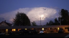
You can just see the bike mirrors on the left. Was quite a lightshow all the way home.

Also watch your fuel ...stretches in the Park N of Sault have long portions with no fuel.
kurtrules
Well-known member
Your biggest risk for timing is fog that you simply cannot ride in as you go along the North Shore and bitter cold ....9c wet fog is terrifying. You need layers. Even in full daylight ...you can get down to 3 meter visibility.
Would there be early morning/afternoon fog in July on the route? That is something I didn't account for; I was hoping July would be comfortable weather wise.
I had my share of bad luck in foggy, wet weather rides and am in no mood of reliving those experiences.
You might hit construction as well or Tstorms.

Splendid pics! I see that your v-strom has the air hawk over beads. I have one as well, along with a sheep-skin. I tried using the air-hawk under the sheep skin, but to be honest, using it on its own was better. This time on I will try the sheep skin under the air-hawk and see if that adds to long distance comfort.
I normally did Superior in August but just took off last time in June and except for the absolutely wild temperature swings ( 9-16 north of the lake to 32 south of the lake with T storms was a very crazy tho enjoyable ride. )
You can just see the bike mirrors on the left. Was quite a lightshow all the way home.
View attachment 49160
Also watch your fuel ...stretches in the Park N of Sault have long portions with no fuel.
Noted.
Superior never gets very warm so yeah if conditions are right.Would there be early morning/afternoon fog in July on the route?

Lake Superior
Norcorider
Well-known member
Btw, ferry service is resumed. We are doing Algoma Trip from 23 -26 th July and taking ferry back from southbaymouth to tobermory. Booked ferry tickets in advance.
make sure your ride 129
It's only the first 40km or something, up to the "tail of the dragon" (Ontarios very short facsimile thereof) that's any good IMHO. Beyond that...flat, straight, meh. And Chapleau itself, well, uh......yeah. It's there. It's a town. It's, uh. Well...yeah. Don't go unnecessarily out of your way, lets put it that way lol.
Last edited:
Turn left at the end and go towards Wawa, It's a fun ride with some scenery. If you need the gas station is a couple of miles to the right going towards ChapleauIt's only the first 40km or something, up to the "tail of the dragon" (Ontarios very short facsimile thereof) that's any good IMHO. Beyond that...flat, straight, meh. And Chapleau itself, well, uh......yeah. It's there. It's a town. It's, uh. Well...yeah. Don't go unnecessarily out of your way, lets put it that way lol.
Bring your own tie down straps. They just have course manilla rope.Yes, I have booked the ferry back to tobermory on the 4th July.
kurtrules
Well-known member
make sure your ride 129 to chapleau
It's only the first 40km or something, up to the "tail of the dragon" (Ontarios very short facsimile thereof) that's any good IMHO. Beyond that...flat, straight, meh. And Chapleau itself, well, uh......yeah. It's there. It's a town. It's, uh. Well...yeah. Don't go unnecessarily out of your way, lets put it that way lol.
Turn left at the end and go towards Wawa, It's a fun ride with some scenery. If you need the gas station is a couple of miles to the right going towards Chapleau
NotedBring your own tie down straps. They just have course manilla rope.
I unless you have good reason not to the stretch between Wawa and Chapleau, and Chapleau down to the TransCanada again (with the exception of the very brief twisty section of 129) is skippable imho. The stretch from the soo up to Wawa and north is far more enjoyable.
I'll do one route going up and the other going down just to experience both.
Sounds good, and I understand not wanting to backtrack 100%, however having done most of the roads up that way several times now I would choose to ride the stretch between the Soo and Nipigon/Wawa (nice roads and very scenic in areas) over again having done the chapleau loop once now.
But I get wanting to see new roads.
If your experience is anything like ours was last year, try to get into Chapleau at a decent time, they Roll in the sidewalks around 4 PM and the only place we could find for dinner was Subway or pizza, and the pizza was over an hour wait.
The motel we stayed at was 2 star at best.
kurtrules
Well-known member
Right. Noted.Sounds good, and I understand not wanting to backtrack 100%, however having done most of the roads up that way several times now I would choose to ride the stretch between the Soo and Nipigon/Wawa (nice roads and very scenic in areas) over again having done the chapleau loop once now.
But I get wanting to see new roads.
If your experience is anything like ours was last year, try to get into Chapleau at a decent time, they Roll in the sidewalks around 4 PM and the only place we could find for dinner was Subway or pizza, and the pizza was over an hour wait.
The motel we stayed at was 2 star at best.
kurtrules
Well-known member
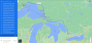
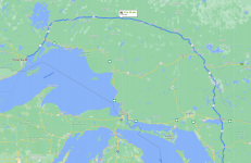
I have started to plan out the route and places to stop/see on the way towards thunder bay. Here's what the final version of what the first two days look like:

Then I plan to spend an extra day in thunder bay, and then 2 days return. I was mapping fuel stops on the way as my target time of departure is around 2am on the coming Wednesday. I haven't booked any accommodation for now, as the plan is to ride as far north as possible on the first day, and then decide. Largely depends on the amount and duration of rain on those days.
For the return, I was initially thinking of the 101 to Chapleau, 129 down and then the ferry from Manatoulin back. But now, I am also considering the 11 all the way back. What I want to ask is, that should I choose the 11 over the 129 and ferry? Would it be worth it? I have not ridden on any.


