


You are using an out of date browser. It may not display this or other websites correctly.
You should upgrade or use an alternative browser.
You should upgrade or use an alternative browser.
Mapping tools/program
- Thread starter rider1106
- Start date
Splash
Well-known member
Anyone have any recommendations on a computer mapping tool to plan trips?
I have always used google maps but it is very slow and not very reliable (i.e. I have no idea how to edit a "line" on a map once I created one).
Cheers,
In Google maps, create your start point and end point then drag the line anywhere you want.
As for computer software, I use Mapsource.
pnosko
Member
I use Microsoft Streets & Trips on the computer and then export directly to my Garmin as a .gpx file which the Garmin can then turn into my route. This works extremely well. On multiple day trips I always have my netbook with me so if I change my plans I can edit the route on Streets & Trips then reload into the Garmin which can all be done offline with no internet connection.
I often use Google Maps online to do some pre-planning / browsing of potential routes, but once I get a basic idea of what route I will take I perfect it in Streets & Trips.
I often use Google Maps online to do some pre-planning / browsing of potential routes, but once I get a basic idea of what route I will take I perfect it in Streets & Trips.
Thats my recommendation to a tee right down to taking my netbook on trips lol
I use Microsoft Streets & Trips on the computer and then export directly to my Garmin as a .gpx file which the Garmin can then turn into my route. This works extremely well. On multiple day trips I always have my netbook with me so if I change my plans I can edit the route on Streets & Trips then reload into the Garmin which can all be done offline with no internet connection.
I often use Google Maps online to do some pre-planning / browsing of potential routes, but once I get a basic idea of what route I will take I perfect it in Streets & Trips.
rider1106
Well-known member
I like this. Doe the software come preloaded with POI's such as gas stations?Thats my recommendation to a tee right down to taking my netbook on trips lol
I actually really like Google Maps for planning a trip, just wish there was an easy way to export to gpx. Surprisingly Harley of all companies has a very good mapping app on their web site, just google Harley ride planner. Almost as good as google maps, but a little clunkier, however you can export to gpx straight off the site.
Thanks for the tip - this should be put up in the sticky
http://www.motowhere.com/listpaths/srchkey/ontario
http://www.motowhere.com/listpaths/srchkey/ontario
rider1106
Well-known member
Thanks, will keep this one in mind!I use motowhere as per my signature below. I find it very easy to use compared with google.
macrider
Well-known member
Starship, perhaps you can help me a bit with the Motowhere.
Once I have created a map, I am ready to load it into my GPS, how do I do that?
I clicked on "import File" then it says I need to get a .gpx file.Is that a program I need to download to make Motowhere work?
I am not that good with computers.
I have been using the Harley Ride Planner as theres no need to worry about .gpx files,, but I still would like to know how Motowhere works.
Well, google makes it pretty easy to collaborate, and the view/zoom feature along with the terrain maps I find exceptional, so here's how I plan a route and load it into my gps:
Google maps using the get directions feature I create something like this:
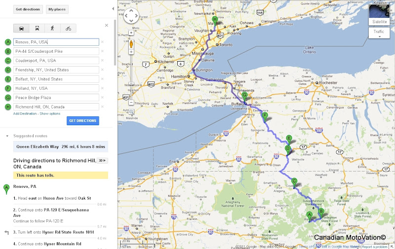
And share the google link to all parties until we all agree on a route, then I take it and at the bottom of the left hand column, save it and "Create new map".
When I go to my maps, it's available as a download as a KML file, then I use www.gpsvisualizer.com to convert it to a gpx, download and import it into Mapsource to do final tweaking and then share out the GDB file to all the participants. Every city or destination you used to shape the route will become a waypoint in the end product, so use them strategically to alter your route rather than "dragging" the blue line, that will create an awesome track, but then you'll need to really tweak the route to make something out of it in Mapsource.
Routing you have to do manually, but the tracks are excellent and need minor tweaks, and if you ride offroad, then you'll love the tracks you get from this method. I'd happily follow a blue line of my proposed route, then to trust the auto-routing adventure seeking adlibbing tendency of my Garmin.
Google maps using the get directions feature I create something like this:
And share the google link to all parties until we all agree on a route, then I take it and at the bottom of the left hand column, save it and "Create new map".
When I go to my maps, it's available as a download as a KML file, then I use www.gpsvisualizer.com to convert it to a gpx, download and import it into Mapsource to do final tweaking and then share out the GDB file to all the participants. Every city or destination you used to shape the route will become a waypoint in the end product, so use them strategically to alter your route rather than "dragging" the blue line, that will create an awesome track, but then you'll need to really tweak the route to make something out of it in Mapsource.
Routing you have to do manually, but the tracks are excellent and need minor tweaks, and if you ride offroad, then you'll love the tracks you get from this method. I'd happily follow a blue line of my proposed route, then to trust the auto-routing adventure seeking adlibbing tendency of my Garmin.


