Looking for any mapped routes people have going towards perry sound, 518, towards calabogie, etc | GTAMotorcycle.com

Looking for any mapped routes people have going towards perry sound, 518, towards calabogie, etc

KWDRZ

Well-known member
Hoping to get out next week for a longer ride, something all day starting from gta, can anyone share their google maps/.gpx routes hitting all the good stuff in this general direction?

Been looking at old threads but I've confused myself about what to actually do and skip.
 
Any questions after you check it out - just ask.

That thread has a ton of good info, damn.

I think I'm going to just get my feet wet up there with your pre planned route: here

One possible thing, leaving from kw this time, is there anything you would recommend to cut off to shorten it slightly as a day trip, that maybe isn't as good as the rest? I tend to like the more technical stuff than the "boring but scenic". ;)

Appreciate the help
 
This link took almost an hour off the route and removed Southwood Road only, since it's in pretty bumpy shape and while it's certainly technical, it's not a great road right now for getting into a nice flow with the cornering.
 
This link took almost an hour off the route and removed Southwood Road only, since it's in pretty bumpy shape and while it's certainly technical, it's not a great road right now for getting into a nice flow with the cornering.

Thank you so much, very helpful, doing this next Friday. Will report back!
 
I can't open the route on my phone for some reason. When I click it from here on my computer it shows up fine, but on my phone when it opens in the app it shows the route as like 50 minutes. No idea what's going on.
 
It's a weird iPhone thing. There is a workaround for it but just can't recall what. Maybe open it in one of the mapping apps?
Maybe @MacDoc will know?
 
There was a thread in here where someone complained about the same thing and someone else posted the workaround. I tried it out and was impressed at how easy and effective the work around was. Just can't recall which thread it was, but maybe a skillful search will find the thread.
 
Maybe this but no idea how to get it on to the phone

It can also be exported to KML files and then switched to GPX etc in Furkot.

Login to Google My Maps.
  1. Select and open the map you want to export.
  2. To the right of the map's title, click on the icon: Three Vertical Dots.
  3. Select: Export to KML/KMZ.
  4. Under the heading, Export to KML/KMZ, click on the drop-down menu the currently says: “Entire Map”.
  5. Select which layer you want to export.
 
Last edited:
Thanks guys, I've been on a deep dive trying to find the work around. Lots of apps out there and having a hard time finding one that does everything I want.

I will look into the above and see if it works out
 
I currently use MyRouteApp to build my routes. It replaced the formerly awesome TYRE which is no longer available.

Using MyRouteApp, you can save the files as a gpx or whatever file. I then open up the file using the version of TYRE on my computer and it loads onto my GPS.

Sorry, but I don't use my phone as a GPS so I'm a bit clueless about those. Maybe do a search on ADVRider since they have a pretty big dedicated GPS sub forum there.
 
No worries I appreciate all the help. I re-did the route with the line drawing feature of "google my maps" (different from google maps, kind of weird). From "my maps", you can export a .kml, and I am able to open it on my phone no problem on a variety of gps apps. Shows the whole route but none have turn by turn that I've found so far. Currently looking for an app than will do turn by turn from a .kml. I am on the right track though.
 
Happy to report I figured out what to do, not elegant as I need to recreate the routes with a manual road following, and the stops are limited to a max of 10 when making a route. Which can be a problem because when drawing to make a route, if it sees there is a faster way to get to where you're going, it try's to change the route and avoid roads that you want to go on. It's always looking for the fastest route so you need to drop a "stop" before it tries to change the route. And then continue on down the path with a new stop so it doesn't use its magic to change the road and avoid everything you want to hit. I was just barely able to map this 5.5 hr route with my 10 points.

After creating it in google my maps, export to .kml. From there using kml2gpx.com, I converted to a gpx, which is easily opened as turn by turn directions from a few apps, my favourite so far being calimoto. For some reason apps do not like .kml as much, you can open the route and see the birds eye overview with the 1-10 stops but no navigation besides the gps follow function.

Very glad this is figured out. Thanks again for the help. Probably will keep mass downloading gps apps and see if I find anything better but calimoto seems nice so far. It also has a route tracking function.

Typically I use an iPhone and "Scenic" is the top of the pack, but at the moment I'm on an android phone because my iPhone is broken and scenic is not available for android. Otherwise I would be using scenic for gpx files.
I did the same exact thing - using google maps on my PC to draw out the route - but split the map after 10 points. Then saved it in mymaps, shared the link to my email which will open in my android phone. Now the most important thing is
(Make sure the stop points you choose are not away from the main route/road as it will drive you crazy when driving. You will hear turn right and your destination is on your right for example on one of the waypoint and then google will autoroute you the fastest route to your final destination before you realize you have gone too far).

/Dex

Sent from my SM-G930W8 using GTAMotorcycle.com mobile app

How did you turn a "my maps" route into a turn by turn navigation? Whenever I tried to view it in google app on my phone it was just the route overview and not actually a turn by turn. I had to export the kml file then gpx as stated and open it a third party app, I couldn't get google to actually do the turn by turn of a my maps route.
 
How did you turn a "my maps" route into a turn by turn navigation? Whenever I tried to view it in google app on my phone it was just the route overview and not actually a turn by turn. I had to export the kml file then gpx as stated and open it a third party app, I couldn't get google to actually do the turn by turn of a my maps route.
Its long-winded, this is how I do it on my PC:
  • From My Maps click on the three vertical dots on the layer you have created
(screenshot below shows to maps that i created to limit to 10 waypoints- so map1 is start of ride, map 2 is return route). You will need to get directions for both)
2020-07-10 09_37_55-Southwood Rd 13 - Google My Maps - Brave.png
  • Select step-by-step-direction
2020-07-10 09_39_04-Southwood Rd 13 - Google My Maps - Brave.png
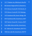
  • Copy just your way point address into a text editor
  • go to maps.google.ca
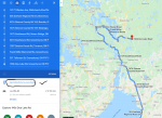
  • Add your waypoints exactly the way you have it on the mymaps
2020-07-10 09_44_20-13177 Warden Ave to 1906 Doe Lake Rd, Gravenhurst, ON P1P 1R3 - Google Map...png
  • Look for option 'Send directions to you phone' -> if you are signed on you will your phone/email listed. I send it to my email
2020-07-10 09_44_27-13177 Warden Ave to 1906 Doe Lake Rd, Gravenhurst, ON P1P 1R3 - Google Map...png
  • CLick on the link in the email which will provide the turn-by-turn direction2020-07-10 09_44_11-Directions from 13177 Warden Ave to 1906 Doe Lake Rd via 505 Durham Region...png
  • Go crazy few times as google tries to auto-route you and improvise next time :) - keep getting lost and hate google maps - repeat
 
Once you ride the route once or twice, you wont need the GPS anymore to guide you. I just my GPS as a moving map and something to look at when I get bored.
Always keep a paper map with you, just in case of an electrical issue. You can get detailed, regional ones, which are much easier to plan a trip at a glance, rather than constantly zooming and scrolling with a phone or GPS and are better than using a provincial road map.
 

Back
Top Bottom