Careful out there....severe TStorms, hail and tornado warnings

MacDoc

Well-known member
Site Supporter
Burlington - Oakville
2:54 PM EDT Thursday 18 July 2013
Severe thunderstorm watch for
Burlington - Oakville continued

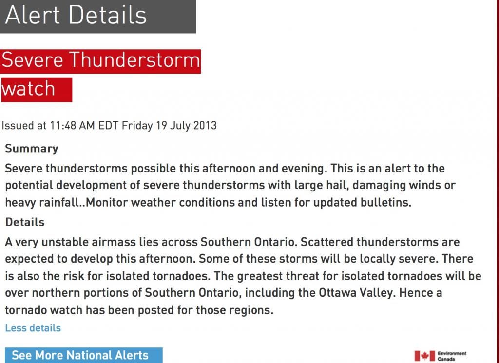
Potential for severe thunderstorms this afternoon into this evening.

This is an alert to the potential development of severe thunderstorms with large hail, damaging winds or heavy rainfall..Monitor weather conditions and listen for updated bulletins.

Conditions are favourable for the development of severe thunderstorms this afternoon and this evening. The main threats with these storms are torrential downpours, damaging winds, and large hail.

Halton Hills - Milton
2:54 PM EDT Thursday 18 July 2013
Severe thunderstorm watch for
Halton Hills - Milton continued

Potential for severe thunderstorms this afternoon into this evening.

This is an alert to the potential development of severe thunderstorms with large hail, damaging winds or heavy rainfall..Monitor weather conditions and listen for updated bulletins.

Conditions are favourable for the development of severe thunderstorms this afternoon and this evening. The main threats with these storms are torrential downpours, damaging winds, and large hail.

Mississauga - Brampton
2:54 PM EDT Thursday 18 July 2013
Severe thunderstorm watch for
Mississauga - Brampton continued

Potential for severe thunderstorms this afternoon into this evening.

This is an alert to the potential development of severe thunderstorms with large hail, damaging winds or heavy rainfall..Monitor weather conditions and listen for updated bulletins.

Conditions are favourable for the development of severe thunderstorms this afternoon and this evening. The main threats with these storms are torrential downpours, damaging winds, and large hail.

Caledon
2:54 PM EDT Thursday 18 July 2013
Severe thunderstorm watch for
Caledon continued

Potential for severe thunderstorms this afternoon into this evening.

This is an alert to the potential development of severe thunderstorms with large hail, damaging winds or heavy rainfall..Monitor weather conditions and listen for updated bulletins.

Conditions are favourable for the development of severe thunderstorms this afternoon and this evening. The main threats with these storms are torrential downpours, damaging winds, and large hail.

Tornado warning have apparently ended.
 
HAH! I took the car today. I could smell it this time....
 
i got caught in some bad rain in nobleton yesterday.. not quite a tornado but hard rain.
 
I hope it does, finally it'll cool everything off...next week is looking awesome for riding! Mid-20s with mid-teens for evening temps.
 
I took my chances to bike to work today. Hope the weather holds up!!!


Sent from my iPhone using Tapatalk
 
Anyone risking it today? I toyed with the idea but the winds look ridic so I'm going to get swept away lol
 
These "Watch" alerts are active almost every day in the Summer when it get's really hot.
Don't let them spook you.

D
 
Not for severe they aren't everyday watched....Tstorm watches yes.....and after this stretch of weather the break will be dramatic....I've been in a few and they are scary *****.
So yeah - ride but
a) rain gear
b) keep an eye on the sky

The only reason it's a watch is because there is no knowing where a severe cell will arise and two of them collided last week over Toronto.
Better to know up front and each rider can make their own decision.

I don't mind bad weather but have learned to respect severe cells. Two near misses on funnels is quite sufficient.
 
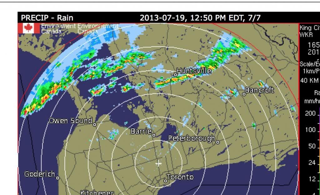
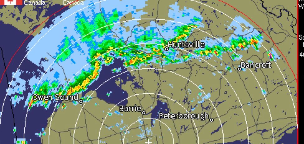
THIS should worry you....any line like that is big time trouble
That just killed my Forks run til it passes.

 
I use RadarNow as an android app but any good radar animation app would be good (radarNow is a US radar app but some of their stations reach far enough north to use). I find they are the most accurate for forecasting precise weather changes. The only thing they don't help with are cells that just pop up. Look at the animation and you can judge, more or less within 15-20 mins or so, when a line of storms etc might pass your locality.
 
I can see this happening.... Went out to pick up a gift @ Vaughan Mills, came out to winds picking up to probably 30-35km/h.

Weathernetwork now says 42km/h winds and 51km/h gusts. Damn... I'm hungry...
 
In bracebridge now and holy crap! The water got way rough, trees blowing over etc. No thanks. Home time.


Sent from my commodore 64 on dial up
 
The only thing they don't help with are cells that just pop up. Look at the animation and you can judge, more or less within 15-20 mins or so, when a line of storms etc might pass your locality.

Yup - one of my worst "caught out" was where the 407 west bound ramp on to the 410 Southbound some 6 stories up.
Could barely keep the bike upright, parked, kickstand down and under the underpass just before the sweeping turn.
Wind was howling and massive rain - looked at the radar when I got home and there were like two tiny ( but intense ) cells and I nailed one head on. Turns out a twister touched down briefly a bit further north.
Best advice - these intense cells move on quickly - just pull off and get to cover.

The other near miss was a front that looked like the one arriving - once more near to a twister touch down, sheltering behind a cube van - and still could barely keep the bike upright and we were stationary on the shoulder.
The van was rocking like a mad thing and the water was ice cold and came up over our boots in minutes.
I don't mind rain but some of these conditions just need to be avoided.
Today has the potential for serious nasty.

That one on the left I'd not want ride through

 
Last edited:
Back
Top Bottom