PacoT
Well-known member
Oh! I've passed by it before but never tried it. I might check it out tomorrow.Since I was in the area
Burger...


Oh! I've passed by it before but never tried it. I might check it out tomorrow.Since I was in the area
Burger...
Do it! It's kinda famous, and very busy, but they move things a long pretty well. Decent burger!Oh! I've passed by it before but never tried it. I might check it out tomorrow.
What kind of GPS did you lose and what kind are you replacing it with?
A Garmin XT3 has replaced an unloved (hated, actually) Garmin 396. I've not ridden with the new unit yet, but it's readily apparent it's infinitely better than the piece of junk 396.
 They were really pushing you towards the flagship 595.
")
Sorry to hear that. Hitting wildlife is always a risk while riding- one of my biggest fears.Looks like I'll be doing my Okangan run solo.
'Buddy crashed this morning
Hit a deer.
Taken to HGH... in surgery now with a collapsed lung, broken ribs... possible neck injury.
Bike is likey a write off.
What a ****** Sunday.
Sorry to hear that. Hitting wildlife is always a risk while riding- one of my biggest fears.
 ) and back, and overall it was a great day, around 650 km in total. The weather was beautiful in the morning, although it got a little hot toward the end of the ride.
Is it better again? Last time I was there, decades ago, the burgers were raw. We stopped there for years when I was a kid, because you could climb all over the trains, and they had a rabbit pen. We used to eat our burgers on the roof of the caboose. I'm pretty sure that's no longer allowed.Do it! It's kinda famous, and very busy, but they move things a long pretty well. Decent burger!
Every season without fail my first longish ride was GTA - Fort Erie via QEW -> Niagara parkway to NOTL.It's a nice road to take. Especially if you have never done it. From Niagara to Fort Erie is the best as you are right next to the water.
Great for weekday runs, maybe not so much on weekends as Niagara can be jammed.
Seemed good to me (definately wasn't raw), I heard about the dip in quality, but like you I had not been there in a long time.Is it better again? Last time I was there, decades ago, the burgers were raw. We stopped there for years when I was a kid, because you could climb all over the trains, and they had a rabbit pen. We used to eat our burgers on the roof of the caboose. I'm pretty sure that's no longer allowed.
I saw Frank Mahovlich in the Tim Horton's up the road once.
Well hopefully you can get back out there on the next bike?Every season without fail my first longish ride was GTA - Fort Erie via QEW -> Niagara parkway to NOTL.
Gorgeous views but 50-60kph limits all the way.
Very chill way to start the season.
Maybe. But right now I’ve got a host of other issues to deal with financially.Well hopefully you can get back out there on the next bike?
you dont have a bike? What happened to the scrambler?Maybe. But right now I’ve got a host of other issues to deal with financially.

Sold in March / April of this year.you dont have a bike? What happened to the scrambler?
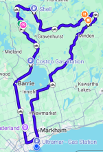
The link for this very useful map can be found in shanekingsley's signature.Yesterday I went to ChatGPT and asked it to plot me a nice 6-8 hour ride from Toronto. I didn't want to go to Muskoka or the Haliburtons because I'm there quite a lot anyways.
What an exercise in frustration that was. It kept asking me questions, telling me where to go and what it needed to know before it could give me a GPX. Finally I told it "Just give me a GPX now please" and then it tells me it can't actually give me a GPX.
Went to Gemini and it ended up telling me to input some waypoints into BaseCamp. It kept giving me instructions for a different version of BaseCamp and I kept having to upload screenshots so it could figure out what I actually needed to do. At one point it suggested using coordinates. The first coordinate put the waypoint right in the middle of a lake. When I pointed that out, it said "Good catch".
Finally enough time had passed and I just said "F it, I'll just go to Forks of the Credit".
That is pretty neat thanks for sharing. I think I found it here:Next destination…just because it’s kind of neat
File:Irvine Lake Airstrip - June 2004 (38956227605).jpg - Wikimedia Commons
commons.wikimedia.org
An old airstrip. Used by dark skies enthusiasts mostly.
Note that Google Maps doesn’t have the right accurate directions. It’s close but put on satellite view and you’ll see it’s closer to the highway.
Just off highway 41 on the way to Bon Echo park. This is a really nice part of highway 41 and it’s part of some of my favourite rides either North West out to Bancroft or east out to Ompah/Plevna.