
Noticed the same. They were pretty accurate the past few years, but completely useless this year.I used to defend TWN as it always worked for me. The complaint used to be that the picture was of a sun with partial cloud cover, but the weather didn't look like the picture. At least now you guys are looking at POPs and mms. But TWN has been really unreliable lately, compared to years past IMO. I think their weather models are outdated, maybe due to global warming? Anyways, I agree that the radar map is the best way to determine the weather you'll face.


You are using an out of date browser. It may not display this or other websites correctly.
You should upgrade or use an alternative browser.
You should upgrade or use an alternative browser.
The Weather Channel and Riding
- Thread starter cbcanada
- Start date
So what do you guys think it'll be this weekend?
They say Saturday is 60% showers and Sunday is 40%. That's not really helpful lol.
Sat. Morning
Cloudy with showers
Feels like 23
P.O.P: 60%
Rain: Close to 1 mm
Wind SW 20 km/h
Wind gust 44 km/h
Humidity 78%
Sat. Afternoon
Chance of thundershowers
Feels like 37
P.O.P: 40%
Rain: Close to 1 mm
Wind SW 25 km/h
Wind gust 45 km/h
Humidity 66%
Sat. Evening
Chance of thundershowers
Feels like 35
P.O.P: 60%
Rain: 2-4 mm
Wind W 15 km/h
Wind gust 33 km/h
Humidity 66%
Looks like gusty winds with light rain in the morning. Should be rideable without getting very wet, but the wind adds unpredictability I think. Probably dry in the middle of the day, or if it rains it will still be rideable especially if it's 1mm in thunderstorms, cause then you can just wait 'em out for 20 minutes or so and keep going.
Evening is interesting. Historically, the threat of thunderstorms has always seemed to be the greatest in the evening, but this is one of those things they've been way off in predicting this year. So do you go with long-term history and expect that we'll probably have some good storms (and still only 2-4 mm so waiting them out is still an option), or short-term history and count on not getting hit? Dunno.
TorontoCruser
Well-known member
the weather network is usually wrong, ergh
Nah - use the radar
You can usually see what's coming a couple hours ahead.
http://weather.gc.ca/radar/index_e.html?id=WKR
Most comes from the west so look at Exeter as well for a larger view
http://weather.gc.ca/radar/index_e.html?id=WSO
and make sure you hit the animation button to see which way it is heading. For instance that Exeter radar shows something down around Windsor that might affect my ride toward Stratford today.
I've found it very accurate.
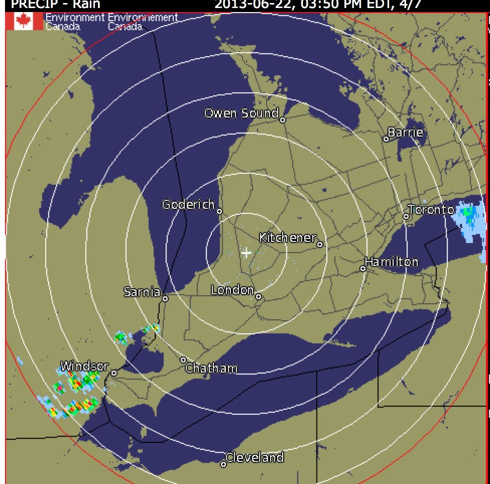
Tstorms tho can pop up so you need to check when they are predicted as to where they are.
Panned out kinda like expected, at least in Thornhill. No rain at all in the evening, keeping with the current trend of fewer late-day thunderstorms than I remember in previous years.Looks like gusty winds with light rain in the morning. Should be rideable without getting very wet, but the wind adds unpredictability I think. Probably dry in the middle of the day, or if it rains it will still be rideable especially if it's 1mm in thunderstorms, cause then you can just wait 'em out for 20 minutes or so and keep going.
Evening is interesting. Historically, the threat of thunderstorms has always seemed to be the greatest in the evening, but this is one of those things they've been way off in predicting this year. So do you go with long-term history and expect that we'll probably have some good storms (and still only 2-4 mm so waiting them out is still an option), or short-term history and count on not getting hit? Dunno.
Sunday:
Sun. Morning
Chance of thundershowers
Feels like 28
P.O.P: 40%
Rain: Less than 1 mm
Wind SW 10 km/h
Wind gust -
Humidity 88%
Sun. Afternoon
Chance of thundershowers
Feels like 37
P.O.P: 40%
Rain: Less than 1 mm
Wind SW 15 km/h
Wind gust -
Humidity 83%
Sun. Evening
Variable cloudiness
Feels like 35
P.O.P: 20%
Rain: -
Wind SW 15 km/h
Wind gust -
Humidity 74%
So a constant threat of light rain throughout the day. Should be rideable IMO.
Sheer geniosity.
First I thought spelling error. Then I thought no that can't be. So I googled it. Son of a gun. I did not know that. Learning stuff left right and center around here. Will work geniosity into future postings, prolly sooner than later. Thanks.
First I thought spelling error. Then I thought no that can't be. So I googled it. Son of a gun. I did not know that. Learning stuff left right and center around here. Will work geniosity into future postings, prolly sooner than later. Thanks.
I hope this was clear. Will provide flow chart on an as needed basis.
I use radar and find it very accurate http://weather.gc.ca/radar/index_e.html?id=wso
I get my weather data from Environment Canada's webpage which includes radar. An iPhone app that pulls that same Canadian data is "Degrees" which is the one I use: https://itunes.apple.com/ca/app/degrees-accurate-canadian/id430737738?mt=8
Pick the weather station correctly.
If you're in Durham region the data is provided from Oshawa airport so pick Oshawa or Whitby.
If you're in north Scarborough pick Markham and that data will come from Buttonville airport at 7 and Woodbine unless they moved it.
If you're in Toronto, pick Toronto Island airport.
If you just pick "Toronto" that will give you Pearson airport in Mississauga.
The radar for all of those will be King City, however for temperature, humidity, forecast, etc it does matter which you pick.
I use radar and find it very accurate http://weather.gc.ca/radar/index_e.html?id=wso
How does this work? It's now 8pm and the radar animation is showing the clouds from 6:30 to 7:30.
Pedagogue
Well-known member
fawk TWN, open your door/window, look outside... if wet don't ride, if dry ride.
Yup, this about sums it up this season. Weather reports have been pretty unreliable.
Sent from my iPhone using Tapatalk
shootingrubber
Well-known member
LOL, I am from Ottawa, but in both Toronto and Ottawa TWN is predicting rain every day this week. They also said yesterday that it was going to rain today in Ottawa, but it has yet to. I don't understand how they can be so off all the time in predicting the weather.
Tstorm based rain is difficult to pin down as to timing unlike a front. You DO need a bit of ability to interpret what is going on - radar is your best bet within a 2-4 hour period. Thermal based rain can only be seen within about 1/2 an hour
I had a 340k ride today and dodged a couple of Tstorms - few drops from a blue sky.
Besides when it's 30 degrees who cares if you get wet
I had a 340k ride today and dodged a couple of Tstorms - few drops from a blue sky.
Besides when it's 30 degrees who cares if you get wet
Last edited:
So a constant threat of light rain throughout the day. Should be rideable IMO.
So not much threat of rain after all, so was very rideable. TWN wins this one.
Kri$han
Well-known member
How does this work? It's now 8pm and the radar animation is showing the clouds from 6:30 to 7:30.
Yeah - Radar images can really only tell/show you what it's currently like, and what it has been previously been like... they can't tell the future LOL.
Most radar weather sites, however, have "prediction" models, which is how they guess where the clouds are going and how they're moving. Examine the radar animation closely and you can see when it's giving a "forecast" and when its showing "current data".
Anyone that uses a radar that gives >4 hours of previous weather data, please post here (even if it's a paid service) - I'm looking for a good one.
****in' meterologists on TV analyse the past 24 HOURS of cloud movement, humidity and temperature data - but on their websites we only get to see an hour's worth. I guess they figure that if they showed us everything, we'd never watch or listen to their ****** reports again.
Kri$han
Well-known member
So not much threat of rain after all, so was very rideable. TWN wins this one.
Yes! and with this much heat - gettin' a little wet is okay with me
")
Yeah - Radar images can really only tell/show you what it's currently like, and what it has been previously been like... they can't tell the future LOL.
animation shows you where rain is heading so yes you can tell the future
As a rider that's really the only info you need aside from watching for storm warnings.
I didn't know for sure I would be in rain yesterday but based on the nature of the weather and the radar it was likely and I skipped home with a few drops.
It's not all that mysterious and King City gives adequate cover for day rides.
The hourly forecast will give general temps - I use Orangeville as it's away from Lake Ontario which alters readings.
ANY hot summer day is likely to have convective storms in the afternoon.
It's not a "guess" where the clouds are going....the radar shows the progress of the clouds and the speed over a short period.
However that does not apply to convective storms which "pop up" for that you need to watch the sky and understand what you are seeing.


