Route Planning for GPS - MyRouteApp | GTAMotorcycle.com

Route Planning for GPS - MyRouteApp

shanekingsley

Curry - so nice it burns you twice
Site Supporter
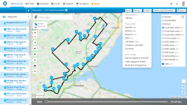
Anyone here using MyRoute App to plot their rides?

I've been using the free version for a few years and it's simple to use for what I want, which is currently plot a route, and quickly transfer it it my GPS. Previously I was using Tyre (also great) and before that it was MapSource from Garmin.

I just got an email offering the Lifetime Gold subscription for $99 and am debating buying it. Looks pretty cool for those who like to really tour with the ability to overlay many different mapping layers and streetviews all the while planning routes. Might be super helpful for avoiding gravel, or intentionally taking rougher terrain. I'm sure there are more differences, but I just haven't looked into it yet - curious if anyone else here has the Gold membership.

This video outlines the differences between the free version and the gold.
 
Last edited:
I used it years ago, just the free version. After a while I found I preferred the detail level in Google maps more appealing and less cluttered or distracting. Between that a basecamp (which I dislike) I can get stuff done without having another expense or tool to use.
 
Will have a closer loom bit I like Scenic and use it with my iPhone.

Quick and easy to plot a ride on the phone and modify on the fly without having to load it to another device.

My Zumo had been relegated to the topcase or for quick point to point use.

Absolutely love the robust build , waterproof and glove friendly screen of a Zumo but add full phone integration through Android Auto and Apple CarPlay and will happily purchase my next Garmin.
 
I used it years ago, just the free version. After a while I found I preferred the detail level in Google maps more appealing and less cluttered or distracting. Between that a basecamp (which I dislike) I can get stuff done without having another expense or tool to use.
Not sure if the level has increased since you last used it, but when I'm planning a longer ride, I was often using Google Maps at the same time to add in specific gas stops or restaurants and things like that. I do wish the free version of MyRouteApp had a comparable level of detail like Google Maps.

I decided to just buy the Gold Lifetime subscription, and see that it opens up a ton of other map options including Google Maps and traffic (which could be good if you are using a mobile device):
1629466020315.png
 
Last edited:
Will have a closer loom bit I like Scenic and use it with my iPhone.

Quick and easy to plot a ride on the phone and modify on the fly without having to load it to another device.

My Zumo had been relegated to the topcase or for quick point to point use.

Absolutely love the robust build , waterproof and glove friendly screen of a Zumo but add full phone integration through Android Auto and Apple CarPlay and will happily purchase my next Garmin.
Indeed if there was Apple Car Play integration with my Zumo, that would be awesome.

Since my iPhone is my primary phone, I'm hesitant to have it serve double duty as my GPS too. If there is one thing I really like about the Zumo is how tough it is and beating they can take.

I haven't tried out the Scenic App yet, but know that quite a few people use it and seem to like it. I did read that the MyRouteApp has a mobile platform, but I'm not sure how it compares to Scenic in it's functionality and ease of use. If you do want to give the MyRouteApp a closer look, then read this article - the features it describes is what made me decide to buy the Gold Lifetime Membership. About 1/3 of the way through the article is where it starts getting into the various features.

Edit: Here's another few screenshots.
Using the free version, you can also export the route into many different file types and you can see the distance between the various points on the left, which is helpful when trying to plan gas stops.

1629466851732.png

For the Gold membership, I'm now pretty happy I went with it, because I often want to reverse a route and see if that's a better way. I can now also plan a multi day ride as one long route and then quickly split it up to 1day chunks.
1629468204596.png

On my trip to BC last year, the amount of time I spent trying to accurately plan out 12hr days while properly syncing up the days with motels and motorcycle repair shops took a fair bit of time. Now I can do all of that with one click.
1629468626994.png

1629468666878.png

There's also access to a discussion forum, tech support and more that I haven't yet explored or am not sure how much I will use.
 

Attachments

  • 1629466814622.png
    1629466814622.png
    372.6 KB · Views: 8
Last edited:
After trying out the sea of route planning apps out there, I always fall back on Gmaps for navigation. The user experience, moreover, the server response time I get from Gmaps is just phenomenal.

I map out a GPX route in motowhere.com. There is a feature there - "View in Gmaps" which I use to navigate through Gmaps.

Never tried out this app, but I will.
Check out some of the screenshots I posted above - they might help you decide if this is a good tool for you.
 
thanks for this Shane

been a long time Tyre user as my TomTom came with a lifetime subscription
something happened awhile back, sounded like a divorce of nerds
and the proggie is next to useless now

I use google maps as well alongside the route planning app
will try MyRoute as a substitute for Tyre
Happy to help and I really liked Tyre too.

I’ve been using this free version for a couple years now and am quite comfortable with it, so if you have any questions, don’t hesitate to ask.
 
  • Like
Reactions: J_F
I'm not techy so I mostly make up a route in my mind then try to remember the road names I want to turn onto as they come up on my GPS. If I forget the name or which direction to go it's still quicker to look it up on my phone (zooming out resolution on BMW gps sucks) than it is to plan the route in an app then into the gps. If I could plan routes in an app and into my gps quickly I'd be open to it.
 
I'm not techy so I mostly make up a route in my mind then try to remember the road names I want to turn onto as they come up on my GPS. If I forget the name or which direction to go it's still quicker to look it up on my phone (zooming out resolution on BMW gps sucks) than it is to plan the route in an app then into the gps. If I could plan routes in an app and into my gps quickly I'd be open to it.
I think you have seen some of the routes that I have done where it’s a long day of many twisty roads. Using the free version of this app I can usually map out a route and transfer it to my GPS in about 15 minutes.

If others are coming for the ride and we need to stop for gas more often, then it takes me a bit longer to make sure we have a gas stop every 150-200km or so. When I ride alone or with bikes that have longer fuel range then I don’t bother with the fuel planning and the routes are done really fast.

I think one of the things I also like about a lot of these various apps is that we can save all our old routes. That makes it super easy to recycle an old route again or make minor edits to it and then send it to the GPS.

If others you ride with are using the same app, then often you can also share the routes with them too very easily or allow them to access your routes for them to use as they wish without actually making any changes to your own files.
 
Last edited:
I got a zumo a few months ago, so far I've just been inputting the route directly on the zumo. It's a bit tedious when I want to plan a long complicated route with many points. How do you use MyRoute, on your computer or your phone?
 
I use Google Maps for planning, and then convert the result into GPX file using gpsvisualizer.com. It requires Google API key, which may be a challenge for the less tech savvy people.
 
I use Google Maps for planning, and then convert the result into GPX file using gpsvisualizer.com. It requires Google API key, which may be a challenge for the less tech savvy people.

Best method by far for me. Google My Maps to plot, convert to gpx, and then import to Scenic on iPhone only. The api key is a small hurtle but you get a lot of usage for free before you ever pay for it. I didn't like the route planning apps and prefer to use the simple ui and detailed google maps on a desktop to plot.
 
I got a zumo a few months ago, so far I've just been inputting the route directly on the zumo. It's a bit tedious when I want to plan a long complicated route with many points. How do you use MyRoute, on your computer or your phone?
When I'm out travelling I have also done the same as you where I plot a route directly into the GPS. It's ok in a pinch, but not the way I'd want to go for regular route planning. And yeah, the more complicated a route, the more tedious it becomes doing this directly on the GPS unit.

I use MyRouteApp on my laptop because I like to plan my routes off a larger laptop screen. Then I just connect the USB plug to my GPS and export it directly to the unit. If you laptop and GPS are both bluetooth enabled, then you might also be able to transfer your routes that way, but I'm not sure.

There is a slightly different one for mobile uses here, but I've never used it and can't comment: MyRoute-app Navigation – MyRoute-app: The #1 all-in-one route tool

I know there's tons of other applications and methods out there for route planning. This thread was just to inform others about one of the methods which seems to work well for me and the rides I do with a ton of points that some other methods won't allow.
 
Last edited:
I got a zumo a few months ago, so far I've just been inputting the route directly on the zumo. It's a bit tedious when I want to plan a long complicated route with many points. How do you use MyRoute, on your computer or your phone?
Another way to to be able to create quick routes on the run is to load lots of POI using base camp so you can quickly create a route by linking the favourites.
 
I’m hoping someday that bikes go like boats and cars where electronics go plug and play.

I’m doing a refit on my boat using NMEA. All my sensors connect to a bus that has a small raspberry Pi server with HDMI, wifi, Ethernet and USB I/o. I can use anything with a browser as a dashboard and integrate gauges for speed, tachs, rudder angle, trim, temp, oil pressure, fuel flow, water/gas/waste tank levels, navigation any android or iPhone app as I see fit. I’m planning 12” displays at each helm and 7”displays for the aft deck and galley.

I wish I could rip off the instruments on any bike and replace with an android powered 10”Taft touch screen that I could configure to my liking.

Kickstarter?
 
Last edited:
I’m hoping someday that bikes go like boats and cars where electronics go plug and play.

I’m doing a refit on my boat using NMEA. All my sensors connect to a bus that has a small raspberry Pi server with HDMI, wifi, Ethernet and USB I/o. I can use anything with a browser as a dashboard and integrate gauges for speed, tachs, rudder angle, trim, temp, oil pressure, fuel flow, water/gas/waste tank levels, navigation any android or iPhone app as I see fit. I’m planning 12” displays at each helm and 7”displays for the aft deck and galley.

I wish I could rip off the instruments on any bike and replace with an android powered 10”Taft touch screen that I could configure to my liking.

Kickstarter?
Does that mean you gained access to your floating cottage? Or is this in the planning and acquisition stage and you will get to see the results next year?

Road vehicles are too constrained by regulations. For a while, you could get gauges on your infotainment screen (odbii>bluetooth>android>screen mirror) but that was killed by the nannies. The same technology allowed you to watch videos on the built in screen. Manufacturers can put 92 pages of crap that requires your attention for minutes to do what used to be a sub-conscious button press but consumers are not allowed to make decisions.
 
Did the Streetview go bye bye in myrouteapp? I can't seem to find it.
 

Back
Top Bottom