Hi Ho off to the west and the national parks are open | GTAMotorcycle.com

Hi Ho off to the west and the national parks are open

MacDoc

Well-known member
Site Supporter
Not by bike this time, 3 week road trip with the GF but good practice run for next June when I WILL go cross country on the Burgman.....kid in tow or not. :D

The big parks opened yesterday except Yellowstone.

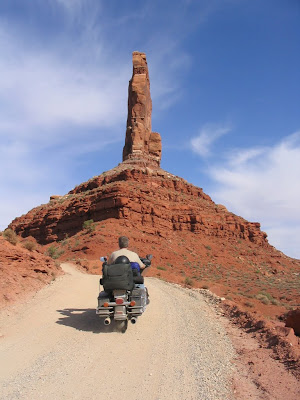
These are all on the route when we leave The Grand Canyon.

Arches National Park (Utah, open October 11-20)

Bryce Canyon National Park (Utah, open October 11-20)

Canyonlands National Park (Utah, open October 11-20)

Capitol Reef National Park (Utah, open October 11-20)

Cedar Breaks National Monument (Utah, open October 11-20)

Glen Canyon National Recreation Area (Utah, open October 11-20)

Natural Bridges National Monument (Utah, open October 11-20)

Zion National Park (Utah, open October 11-20)


We have about 3 days from the Grand Canyon to Yellowstone - suggestions, must sees welcome.

Will post up pics here for inspiration ;)
 
my only suggestion is pack warmer clothes than you suspect you'll need, you'll spend some time at altitude and its chilly in the morning.
 
Thanks - that's one reason I bought that vest with the battery power - dial-a-warm :D
Just have to remember to charge it.

I did warn thin blood GF from tropical Aus to bring her warm jacket. We bought a decent multi-use ( can be one warm jacket or two lighter ones - one a rain jacket ) jacket in France as it was freezing and raining completely unexpected - 8 degrees when that big storm went through in the spring. Gonna be very useful now.
We were also up in the Pyrenees then so worked out.

I recall the last time I was at the Grand Canyon and climbed down and back in a day ( toughest physical thing I've done ).
Significant decades ago.....it was 52 at the top and 82 at the bottom but the river was very cold so you could sit at a certain distance....the range was on a few yards and dial in your comfort zone.

We almost ran into trouble on that trip with cold as we were in Sequoia Nat'l Park very early - no one around ( was April so very quiet time ) and went out running and locked the keys in the car.
Come back sweating and no keys and it's near freezing out....not the smartest thing we've done.

The sunroof was open a crack and managed to get that open and snag the keys with something....dumb kids ;)
 
What vest did you get and why? I tried a Google search on 'dial a warm' and came up empty. I've got two wired ones for the bike, but like the thought of instant heat anywhere.
 
People are always surprised to hear the north rim of the grand canyon is closed Nov to April due to the road being snowed in. Its 8,000ft alt , in comparison I think Whistler is 5,000ft ?
Actually I think the north rim road is closed now for construction.

Its a beautiful area and the topography changes every 50 miles. Keep your gas tank above 1/4, there are some desolate spots on your proposed route.
If you get early starts on your drives watch for black ice till the sun gets well up, the high desert is an interesting place to say the least.

I will be in northern Arizona next week winterizing my house, 18-20c during the day 0/-5 at night .
 
When near Arches NP, be sure to take #128 between Moab and I-70. One of my favourite roads. Also, a little further south, Valley of the Gods Road (see pic)

IMG_1164.JPG
 
Thanks - damn long hike from Barstow - was quite happy to get out of the gunky air around LA.

Lovely day tho. Just caught this late outside where we are staying - was very dark - camera did okay

Nice neighborhood.

Screen%2520Shot%25202013-10-14%2520at%2520Oct%252C%252014%2520%2520%2520%25202013%2520%2520%2520%25207.00.28%2520PM.jpg


Camoflage

Screen%2520Shot%25202013-10-14%2520at%2520Oct%252C%252014%2520%2520%2520%25202013%2520%2520%2520%25207.03.51%2520PM.jpg


Incredibly different from the eastern version.

••••
 
Woot - got lucky and got one of the Eco-choppers all to ourselves on a stunning day

Screen%2520Shot%25202013-10-15%2520at%2520Oct%252C%252015%2520%2520%2520%25202013%2520%2520%2520%25207.48.58%2520PM.jpg


Off to Zion and Bryce tomorrow after a long slog with little sleep

Can see having this area on my cross country next year but stay north in Utah.
 
Cut that pretty fine - one day away - going to do Arches today then decide

Yellowstone National Park waiting for green light, will reopen within hours | KXLF.com | Butte, Montana

Zion was a lovely drive with excellent break for food at the Southern end of the park.

Fascinated by the colours.

Zion.jpg


along the RIver Walk

Screen%2520Shot%25202013-10-16%2520at%2520Oct%252C%252016%2520%2520%2520%25202013%2520%2520%2520%25209.13.54%2520PM.jpg


Cheeky and size large raven at Bryce which we caught just a sunset - we drove to the top a chilly 9,100' elevation with some early snow about and worked our way back down as the sunset approached - loads of deer everywhere and some pronghorns as well.

Screen%2520Shot%25202013-10-16%2520at%2520Oct%252C%252016%2520%2520%2520%25202013%2520%2520%2520%25208.51.12%2520PM.jpg


Screen%2520Shot%25202013-10-17%2520at%2520Oct%252C%252017%2520%2520%2520%25202013%2520%2520%2520%25208.37.01%2520AM.jpg


GF tolerated her aching knee to get down amongst the hoodoos

Screen%2520Shot%25202013-10-16%2520at%2520Oct%252C%252016%2520%2520%2520%25202013%2520%2520%2520%25208.53.01%2520PM.jpg


almost overwhelmed with photos - serious editing session due.

Couple of riders braved the chill - heated gear. Certainly both parks should be high on any western state tour - lovely roads.

Screen%2520Shot%25202013-10-17%2520at%2520Oct%252C%252017%2520%2520%2520%25202013%2520%2520%2520%25208.46.39%2520AM.jpg


This will give a sense of scale of the hoodoos - teeny people

Screen%2520Shot%25202013-10-17%2520at%2520Oct%252C%252017%2520%2520%2520%25202013%2520%2520%2520%25209.04.46%2520AM.jpg

you need to blow it up to see them - the path winds around them
 
Last edited:
GF is enjoying the better camera finally.
She snagged this on fly at 80 mph in low light coming away from Arches National Park.

Screen%2520Shot%25202013-10-17%2520at%2520Oct%252C%252017%2520%2520%2520%25202013%2520%2520%2520%252011.49.04%2520PM.jpg
:rolleyes:

SHe was doing most of the shooting at Arches as I was tired.

Screen%2520Shot%25202013-10-17%2520at%2520Oct%252C%252017%2520%2520%2520%25202013%2520%2520%2520%252011.39.30%2520PM.jpg


You can get a sense of scale against the people

Screen%2520Shot%25202013-10-17%2520at%2520Oct%252C%252017%2520%2520%2520%25202013%2520%2520%2520%252011.41.34%2520PM.jpg


feels like you should tiptoe in case it falls

don%2527t%2520breath.jpg


Screen%2520Shot%25202013-10-17%2520at%2520Oct%252C%252017%2520%2520%2520%25202013%2520%2520%2520%252011.43.08%2520PM.jpg


Screen%2520Shot%25202013-10-17%2520at%2520Oct%252C%252017%2520%2520%2520%25202013%2520%2520%2520%252011.26.28%2520PM.jpg


Brave pair this time of year

Screen%2520Shot%25202013-10-18%2520at%2520Oct%252C%252018%2520%2520%2520%25202013%2520%2520%2520%25206.06.07%2520AM.jpg
 
a chilly wait for my Bday shot - Old Faithful rises to the occasion :D

Screen%2520Shot%25202013-10-18%2520at%2520Oct%252C%252018%2520%2520%2520%25202013%2520%2520%2520%25205.48.21%2520PM.jpg


GF strikes again with the long lens this time...:eek:

Screen%2520Shot%25202013-10-18%2520at%2520Oct%252C%252018%2520%2520%2520%25202013%2520%2520%2520%25206.13.02%2520PM.jpg


a coyote in hunting mode - only a few yards away

Screen%2520Shot%25202013-10-18%2520at%2520Oct%252C%252018%2520%2520%2520%25202013%2520%2520%2520%25206.08.16%2520PM.jpg
 
Great pics Mac.
Make sure you post your route.
 
It's going to be a hodge podge of slabs and wild twisties.

The road up to Glacier Point to get this shot of Yosemite valley would rank very high on difficulty for any rider - add in some kamakazi tour vehicles and it's quite the adventure - white knuckle even in a car. There is one 180 degree tight curve with no guard rail and 3,000' drop below.
But worth the climb.

This was the take home shot from our accidental Yosemite visit ( expensive one at $350 a night ). The scale of half- dome is simply astonishing
You can zoom in some here and see the park community way below dwarfed by the valley walls.

https://picasaweb.google.com/113408714888195024530/GrandCanyon2013#5938912212866920706

No wonder it is such a tourist magnet.
Been there decades ago but never got up to this view at Glacier Point

Screen%2520Shot%25202013-10-25%2520at%2520Oct%252C%252025%2520%2520%2520%25202013%2520%2520%2520%25209.10.17%2520PM.jpg


You could spend a week riding just this area...there were quite a few riders out - some staying at Yosemite. Well heeled - $350 a night at the hotel

http://goo.gl/maps/1SuwO

Screen%2520Shot%25202013-10-25%2520at%2520Oct%252C%252025%2520%2520%2520%25202013%2520%2520%2520%25209.47.17%2520PM.jpg


The valley floor is 3100 feet and you top out over 6,000 in just a few miles up Glacier Point Road - worth zooming in on the Google Map link above the screen shot

Vertigo anyone?? yes those little black dots are cars far far below.

Screen%2520Shot%25202013-10-25%2520at%2520Oct%252C%252025%2520%2520%2520%25202013%2520%2520%2520%252010.02.54%2520PM.jpg


Yosemite should be on everyone's western riding tour list - the GPS was going nuts as we swung around and around the tight stacked curves through redwoods and sequoia
 
Last edited:
Came across this one I didn't know Jude had taken....no guard rail...

Screen%2520Shot%25202013-12-12%2520at%2520Dec%252C%252012%2520%2520%2520%25202013%2520%2520%2520%25207.02.26%2520AM.jpg


Just how good are your tires?? :D
 

Back
Top Bottom