You are using an out of date browser. It may not display this or other websites correctly.
You should upgrade or use an alternative browser.
You should upgrade or use an alternative browser.
Gps or phone app? What do you use?
- Thread starter Clutt-225
- Start date
The Sentinel I'd say "intensive" is perhaps an overstatement. 
Furkot for starters and there are many many more planners. Furkot can export to a variety of formats.
This is perhaps useful and a bit more "intensive".

 advrider.com
and that's hardly the latest.
Snip
Furkot for starters and there are many many more planners. Furkot can export to a variety of formats.
Export
You can export your trip at any time from the Trip drawer. Click the export button and Furkot will create a copy of your trip plan in a selected file format and download it to your computer.
help.furkot.com
This is perhaps useful and a bit more "intensive".
Best Navigation Apps for GPX, Offline Maps
I have 12 years of the best Eastern Riding posted to the New England Riders website. All roads, rides, views, dirt roads, things to see, restaurants,...
 advrider.com
and that's hardly the latest.
Snip
That's where something like Locus comes in. That's the beauty of smart phone apps. You aren't tied to one specific piece of software to do EVERYTHING you want. So you don't have to settle like you do with dedicated GPS's. I use multiple apps to accomplish multiple tasks. For instance, POI and point to point auto routing, I use Here We Go. For following tracks I use Locus. I rarely do manual routing on the fly.
Mad Mike
Well-known member
I really like my old HTC Desire (android) on a powered RAM mount. It has a good size screen, AM/FM radio, tons of music storage, waterproof, and it has the only screen I have ever been able to read in full sunlight. Cardo app makes it easy to control my headset. I've tried Zumo and TomTom Rider GPS and don't find them as useful as having a smartphone on my bars.We dowloaded a 15$ app and used a new iPhone to navigate while riding in the woods last week, it was incredible accurate and recorded every movement faithfully unless you went in tight circles, that messes it up pretty good. Used it to confirm the location of a corner post and it was right on the money. You can even overlay your trail onto a goole terrain map, I don't think you can do that with a regular GPS.
The only downside it you need conductive gloves. Many gloves come that way, I stitched a few strands of lurex metallic thread into the index finger on my glove to solve that.
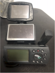
Here are a few of my retired motorcycle Garmins GPS units (streetpilot, Nuvi, GPS II

GreenPlane
Well-known member
I'm using an android phone with a powered mount and either Bluetooth connected coms unit or wireless earbuds. And don't forget about touch-enabled gloves.
Btw, you can run Android Auto and it basically shows the same UI as in the car. Very helpful and all podcasts/music is there + integration with voice assistant and messaging apps.
Btw, you can run Android Auto and it basically shows the same UI as in the car. Very helpful and all podcasts/music is there + integration with voice assistant and messaging apps.
Is there anything that can actually refollow a saved .gpx file, like as if you were going somewhere in google maps normally? Basically I am looking for a turn by turn looking navigation style but all the things I've tried when you select to re-ride a imported .gpx route it gives you a line over a map with your current location that you need to follow "manually". Not the end of the world but having a standard google maps style would be sleek...
It's not the .gpx file that's causing the problem, it's the fact that your saved trail is a bunch of individual GPS points sampled at regular intervals. All the GPS is doing is just joining all the dots together, with no regard to what streets are behind the dots.
In order for the turn-by-turn routing to work, you need to edit the .gpx file and only choose to include specific waypoints out of your breadcrumb trail that the SW can use to create a route around.
Hope that makes sense.
Thanks, you are fast, that makes sense. I quick edited it because I figured it out on Scenic and it tracked the route accurately from what I can tell. I just needed to save the file as a "route" and then you can select it from the main screen and the only premium feature is if you want voice. It seems like its going to work great.
I still enjoy pulling over to check maps, however if we are talking about ap's, this is the one I'm waiting for:
 twistysystems.com
Just over a year ago we ran into a guy in Virginia who was developing a new navigation ap with artificial intelligence algorithms designed to find and string together a route through nearby twisty roads. Selectable levels of exhillaration. I hope to see it integrated with GPS at some point . . . still only in beta for iPhone unless that changed recently.
They plan and hope to create a community with posted rides, road ratings, and reviews as well. Maybe even integrate weather.
The story of how he developed the software is pretty cool.
Youtube promo video here -
(not marketing for them I just think it is so cool ... )
TWISTYroute | Hi Tech Trip Planner | Twisty Systems LLC
Twisty Systems LLC. Use our Hi Tech Trip Planner TWISTYroute to plan an amazing trip with the most exhilarating roads in the world at your fingertips! Trip Planner IOS Route Planning Motorcycles. Create amazing rides in seconds anywhere in the USA, Europe and Asia. TWISTYroute delivers every...
 twistysystems.com
They plan and hope to create a community with posted rides, road ratings, and reviews as well. Maybe even integrate weather.
The story of how he developed the software is pretty cool.
Youtube promo video here -
Last edited:
Just checked out this ap because I hadn't heard of it before. In fact haven't looked for any motorcycling nav ap's in quite a while. I hope our friend hasn't missed his development window. Scenic looks a lot like what Twisty Systems is trying to be. Not sure . . . .I've been using Scenic off and on... really wish it worked on an Android.
... Looked a little more. I think they are not the same thing ... pretty cool though.
so a few days ago i sat down to finally tinker with the BMW phone app and the bike as they are integrated.Used the phone mounted on the bars with a bluetooth headset forever. Will go to OEM Navi for the future long rides (it's removable), stick to phone for the local stuff.
Turns out i can actually get turn by turn navigation displayed (and audio queues) and my music streamed by connecting my cardo and phone to the bike. All controllable via the handlebar controls. Neato!
J_F
Guest
Also, any particular reason for the lockable GPS mount? It's only one button to remove the Zumo from the cradle when leaving the bike.
my Tomtom Rider came with the locking mount
it's a gimmick really
mounting shoe is 100% plastic
a good twist with 2 hands would break the device off locked or not
Aens
Well-known member
OIS cameras lock into a safe position when they are not powered up. Unless you are motovlogging with your forward camera, you are fine. It's why the camera makes a clicking sound when you open the camera app.old phones (ie iphone 7) can be mounted fine. but any relatively newer phone with cameras with OIS will likely be damaged by bike vibration. basically your camera will be busted and will lose ability to focus.
Correct.Do you need cell reception in order to use the GPS on the cell?
A dedicated GPS device uses satellite, so it would be better in remote areas?
Cell phones have GPS built into them for location, but you need data to do anything with it.


