If there’s a lack of traffic cameras one option would be to monitor google / Apple Maps at different times and it’ll give you a good idea of traffic flow.
Google maps can show you the typical traffic conditions based on day of week & time of day.
You can also get average drive time between destinations by selecting arrival/departure times instead of "leave now" option.
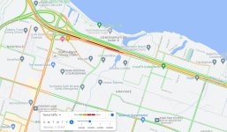
Here is a "typical Saturday @ 11:30am on the QEW just after the Redhill/LINC"
I am not sure how accurate Google Maps is for the areas I am interested in but they are out to lunch
on the route I take across Kingston.
With the adoption of "smart traffic lights" the times can very from week to week on any given day or time.
As I understand the data is collected from those using the app and that implies they are not sure where they are going.
Local knowledge is better at knowing what lane to be in at a specific time and location.
As I understand the data is collected from those using the app and that implies they are not sure where they are going.
Local knowledge is better at knowing what lane to be in at a specific time and location.
I use waze not google maps but presumably they share their traffic data as they are both owned by Alphabet. I almost always have it on while driving. Even if I know where I'm going, cops, crashes, new speed cameras, slowdowns for no reason etc are very helpful to know before you are right in them.
I use waze not google maps but presumably they share their traffic data as they are both owned by Alphabet. I almost always have it on while driving. Even if I know where I'm going, cops, crashes, new speed cameras, slowdowns for no reason etc are very helpful to know before you are right in them.
I use Waze too. It's mostly great for all the reasons you state BUT, one evening in late Sept. I was riding from the north shore of Lake Erie back to St. Catharines. The Linc was closed for 'maintenance' but they didn't tell you the Linc was closed at the junction of the Linc & Hwy 403. The barriers were set up it at the first exit along the Linc after I was already on it. I got off, as I had to, and Waze kept telling me to take routes leading back to the Linc eastbound because it clearly didn't know the Linc was closed. I had to use my own intuition and get back on the Linc westbound to the 403 then to the QEW Niagara bound in Burlington.
That's the only time Waze has failed me completely.
Google maps can show you the typical traffic conditions based on day of week & time of day.
You can also get average drive time between destinations by selecting arrival/departure times instead of "leave now" option.
Here is a "typical Saturday @ 11:30am on the QEW just after the Redhill/LINC"
The map you showed is very accurate, based on my experiences. There's almost always a bottleneck on the QEW when you get to where the Red Hill Pkwy empties into the QEW Niagara bound. If you're coming off the Red Hill to the QEW; the farthest right lane is the place to be. You'll save a lot of time by positioning there until that lane runs out and you have to merge left. By then, normally things are starting to easy up a little.
How much data will I need to buy to run Waze continuosly for a 12 hour period.
I don't have a data plan since I normally only use between $1.00 and $4.00 per month on buy as you need.
Does anybody know of a data prepaid plan?
How much data will I need to buy to run Waze continuosly for a 12 hour period.
I don't have a data plan since I normally only use between $1.00 and $4.00 per month on buy as you need.
Does anybody know of a data prepaid plan?
I'll check my other phone later. IIRC waze uses less than 100MB in a typical month for me. Sorry, I don't have an hourly rate (and it may not necessarily correlate with your trip as I expect it keeps the local maps on board).
Edit:
100-200 mb per month for waze for me. Waze has about 400MB stored in the phone. I have no idea how much of that is a map (maybe nothing, maybe most).
Not sure what the speed ranges of each color are but
I would assume that Green is normal traffic Yellow is congestion Red is heavy traffic Dark Red is Super heavy traffic/accident speed
Don't mean to hijack the thread but
Did anyone notice the different interface of Google maps recently. Within last week. I don't like it. Maybe I am just used to the old interface.
I did some computer work with Waze, Google Maps and Apple Maps tonight.
Came up with some speeds along the Link and QE.
Even in the red zones the average speed is faster than what I get driving East to West in Kingston.
I can run at 70kph and still only average 35kph if you factor in the lights.
I established this using an average speed app.
Unless there is a road closure because of an accident 401 - 403 - Link - QE is the fastest route.
Road construction could alter plans but they are published well in advance.
Border crossings are about the same delay no mater what one you take.
Again everybody is looking at their phone for fastest time so there are no secret routes.
I will keep watching Saturday flow patterns until next Summer to establish trends.
My approach has always been travel with traffic to reduce the stress level.
I find that despite the prevalance of smart phones and these live traffic platforms, the vast majority of road users are idiots and still take the most congested routes or have no idea about which lanes move the fastest along a stretch of congested highway. There are secret routes and ways to shave time on any drive if you don't drive like the masses.
I find that despite the prevalance of smart phones and these live traffic platforms, the vast majority of road users are idiots and still take the most congested routes or have no idea about which lanes move the fastest along a stretch of congested highway. There are secret routes and ways to shave time on any drive if you don't drive like the masses.
I find that despite the prevalance of smart phones and these live traffic platforms, the vast majority of road users are idiots and still take the most congested routes or have no idea about which lanes move the fastest along a stretch of congested highway. There are secret routes and ways to shave time on any drive if you don't drive like the masses.
There is a certain segment of the population that enters a divided highway at 80 and proceeds all the way left as fast as possible even if there is mile of open road in the right lane. The opposite of road iq.
I was watching the live traffic cam at the Peace Bridge US Inspection Plaza at 2:30 to 3:00 today.
The majority of the vehicles raced to the far left lanes to pull into line with 5 to 6 others.
Every so often a vehicle would move to the 2 far right lanes that where open with only 1 vehicle in line.
Then 1 in every 20 vehicles would wander even further right into the 2 empty Car/RV/Bus lanes.
I think we need an app to tell us what inspection lane to use.
So no different than checkout counters I’m a grocery store as new lanes open. Idiots with carts or cars.
On a serious matter. I’m getting very intrigued with your trip. I’m tempted to try something like that also and Ontario seems like the best starter option. May give it a whirl with the Duc sometime but comfort level may blow. Probably not much better than your bike for this trek.
Looking forward to learning more as one of my goals is to ride around Superior.
Then it would not be the Lake Erie Loop.
The all US route was put in place because the borders where closed due to COVID
There is no recognition for doing this route.
This site uses cookies to help personalise content, tailor your experience and to keep you logged in if you register.
By continuing to use this site, you are consenting to our use of cookies.