You are using an out of date browser. It may not display this or other websites correctly.
You should upgrade or use an alternative browser.
You should upgrade or use an alternative browser.
Chase the warmth this Weekend May 9/10/11/12
- Thread starter MacDoc
- Start date
NightShadow
Well-known member
[h=3]Marietta - Ohio[/h]Will be nice on sun for a few days - mid 25's
I am heading down on the 23rd for 4 days as long as no rain.
I am heading down on the 23rd for 4 days as long as no rain.
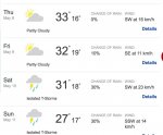
mmmmm ....warm to the south ....very tempting and the front is moving slowly

http://www.accuweather.com/en/weathe...-thun/26622216
Looking good on the weekend even around here

http://www.accuweather.com/en/weathe...-thun/26622216
Looking good on the weekend even around here
Sat
10 May

Sun
11 May

Mon
12 May

10 May
- 30%
- 20°C
Sun
11 May
- 17°C
- 10°C
Mon
12 May
- 21°C
Hmmm- guess heading south is out but now wondering about Lake Placid
[h=2]Texas to New York at Risk for Flooding Downpours, Disruptions to Events[/h]
[h=6]By Alex Sosnowski, Expert Senior Meteorologist[/h][h=5]May 08, 2014; 5:02 PM[/h]
More Sharing ServicesShare|Share on facebookShare on twitterShare on linkedin

A risk of flash flooding will reach from the Gulf Coast to the Tennessee Valley on Friday, while enough downpours farther to the north and east can foil outdoor plans into Saturday.
A slow-moving storm producing severe weather over the Plains through Thursday will shift farther east later this week. While the storm will transition away from severe weather, it can still cause some problems.
A general 0.50 to 1.00 inch of rain will fall from a mosaic of showers and thunderstorms that drifts slowly to the east Friday and Saturday over the Central and Eastern states. In a few locations where downpours repeat, there can be several inches of rain and flash flooding.

Friday will be the wetter of the two days from coastal Texas and Arkansas to Ohio, Indiana, Michigan and upstate New York.
Folks traveling along the I-40, I-55, I-64 and I-65 corridors should be prepared for sudden low visibility and excess water on the roadway. Flight delays are possible from locally strong thunderstorms in Detroit, Indianapolis, Cincinnati, Memphis and Houston.
Saturday will be the more unsettled of the two days from Alabama to New Jersey, southeastern New York state and southeastern New England.

Motorists should be prepared for slow travel along the I-59 and I-81 corridors, as well as a portion of I-80 and I-95. Downpours can cause some minor flight delays in New York City, Philadelphia, Washington, D.C., Pittsburgh, Atlanta and New Orleans.
From southeastern Louisiana to much of Pennsylvania, both days have the potential for disruptive downpours.


