

 Reply With Quote
Starting off;

|
|


I've been watching the Ontario and GTA photo tags and figured it was time to try one in the Golden Hoseshoe (Hamilton, Halton and Niagara areas). I've copied the GTA rules to start out (it seems to work so why not?).
The rules are pretty simple...
1). Post a picture of any place in the Golden Horseshoe that you have ridden to.
2). The bike must be in the picture.
3). The place has to be somewhere anyone can ride to (no private property etc.), on roads (paved or gravel) no trails.
4). Show some photo clues taken along the way to the tag spot (optional).
5). The first person to post a shot of the same spot (including their bike) on this thread gets to place the next tag.
6). No old photos, must be current.
7). The person who finds and posts a tag, must place another tag withing 3 hours of the find post or else that tag is considered void and still open.
The idea to get out riding and have fun, so don't place any tags that are impossible to find, that kinda defeats the purpose.
EDIT:
In order to define the tagging area, it will be the regional boundaries of the Hamilton, Halton, Niagara and Haldimand (not Norfolk) regions.
To assist in their definitions;
Hamilton Region - http://map.hamilton.ca/Static/PDFs/W...Statistics.pdf
Halton Region - http://haltonenvironment.com/wp-cont...map_halton.jpg
Niagara Region - http://www.niagararegion.ca/explorin...al-niagara.pdf
Haldimand County Region - http://www.haldimandcounty.on.ca/upl...oating_Map.pdf
Last edited by coyo; 07-14-2011 at 01:53 AM.
Starting off;
Last edited by coyo; 07-09-2011 at 09:01 PM.
You bugger.
Was just there on Saturday. Couldn't you have posted this 2 days earlier?
.
Yesssss!
I was regularly checking the Kitchener-Waterloo tag game but it is kinda far from me and some of those guys are hard core. Posting a road bridge with a bunch of greenery around... I was completely clueless.
I hope this tag will move at the same pace as the GTA tag moves. I always like to ride to Niagara Falls, however I did not always have a steady reason. Until now.
Happy tagging!
Flat black '08 DL650A
Having posted it on Saturday I thought FOR SURE someone would be out there on Sunday!Originally Posted by SunnY S

I've been watching the other tags and realized that it's a great way to figure out where to go and see new things when you've got a bit of time, the itch to ride... but don't know where to go! I hope it takes off too!
That one is a bit out of range for a week night but this looks like a good game. Just subscribed to the post, I'm in. Thanks Coyo.
St Catharines, Ontario
2010 Suzuki GSXR 600
I'd rather sweat than bleed.
Gear up Buttercup.
for the geographically challenged, a map of the 'playing field' would be helpful just so everyone knows where the boundaries are for this game.
Will keep an eye on this for interesting vistas to visit. Ride safe.
Exactly! There were days when I wanted to go for a ride & I just didin't feel like going to the same old places... but where to go? Answer: photo-tag! I'll keep watching this thread for a chance to get a long-range shot at a tag some weekend. Thanks for starting it up.
I remember some time ago when the Ontario Photo Tag was around Niagara I was considering grabbing one, I was just too slow.
Flat black '08 DL650A
I think you should outline the Golden Horseshoe so no one complains when someone tries to push the outer limits of the area.
As far as I understand it the Golden Horse shoe is Hamilton to Niagara Falls and Down to lake Erie Dunnville Fort Erie area.
Look in the tunk, I think he means trunk.
The golden horseshoe usually refers to all the cities on lake Ontario from the Whitby/Oshawa area around to St Catharines/NOTL. It sounds like we are trying to define the Niagara Penninsula. I am thinking it is Coyo's call to set the boundries. I would suggest Lake Ontario as the northern border, Erie to the south. The Niagara River as the eastern boundry and run it out to particular roads in the west. Maybe Guelph Line over to the 401 and back to the Dunnville area. What do you think Coyo?
St Catharines, Ontario
2010 Suzuki GSXR 600
I'd rather sweat than bleed.
Gear up Buttercup.
Just a suggestion: you might consider using predefined civil boundaries like the existing games (GTA & Ontario). For exmaple you could simply say it has to be in one of: the City of Hamilton (formerly Hamilton-Wentworth), Haldimand County, or Niagra Region.
good idea! I 2nd that motion. because I've heard "Golden Horseshoe" extends from Port Hope to Niagra Falls.
see wiki: http://en.wikipedia.org/wiki/Golden_Horseshoe
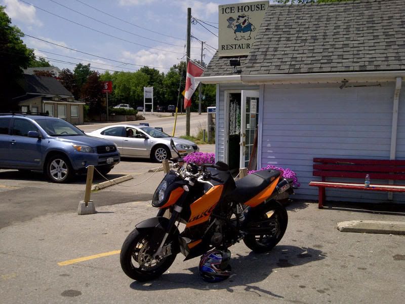
Good points by all and to be honest, I started this thread on my Blackberry while sitting on the bench directly behind my bike seen in the above pic so there was no way I was searching out maps, etc...
I've decided to define the area as Hamilton, Halton, Niagara and Haldimand (not Norfolk) Regions. I included Haldimand but if all feel that makes the area too big then we can limit it to the three regions. I've included links to detailed and zoomable maps (which were too big to attach to the thread) of all four regions so there's no confusion.
Tag away! (someone take my tag!)
Last edited by coyo; 07-14-2011 at 02:02 AM.
I've tried to find where you picture is from with no luck.
Hints?
Look in the tunk, I think he means trunk.

All the rooms of this dwelling would be cold.
the hint is in the photo!
I don't want to ruin the fun, just want to get this moving, so here is a little more direct hint:
http://maps.google.ca/maps?q=19+Main...2,2.22,,0,7.11
Flat black '08 DL650A
LOL.
here's a more subtle hint .. there is a whole thread devoted to this locale ... with pix .... with really nice pix of nice bikes @ this locale ...
<click here to go to thread and see all the shiny bikes!>
 Posting Permissions

Bookmarks