MotoMap for iPhone | GTAMotorcycle.com

MotoMap for iPhone

MacDoc

Well-known member
Site Supporter
If you GPS map on a computer to device read this.

I shifted the title as Furkot is platform independent.
https://trips.furkot.com

Motomap is for iPhones but because Furkot exports in numerous formats the file can work with many apps and standalone GPS ( however you get your maps in )

See below for more detail but it's dead simple to take the route from the Googlemap based Furkot out to a useable GPX file and you can import your existing trips.

What's not to like.

•••••••

The Appl
Looks good

screen568x568.jpeg
screen568x568.jpeg


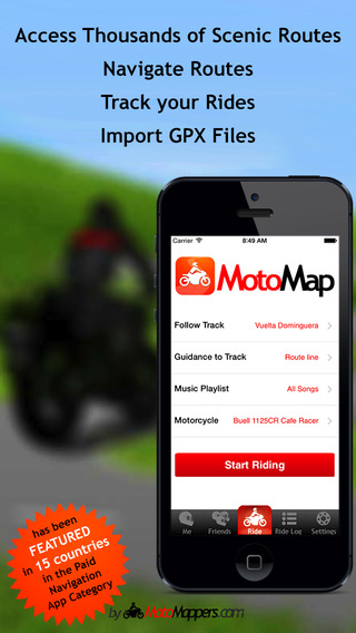
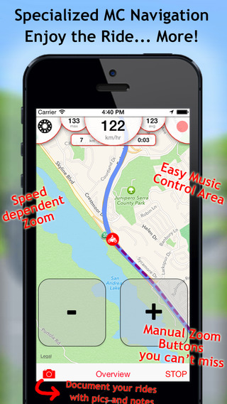
http://www.motomappers.com/motomap.php

Find Scenic Routes

Navigate Routes

Track your Rides

Import GPX Files

Share with Friends

Add pictures and comments to Rides

Control Music Playback with Ease

Zoom automatically and manually

https://itunes.apple.com/app/motomap-gps-motorcycle-navigation/id775798865

•••

This is an overview of some of the Apps available

http://www.motomappers.com/blog/best-gps-motorcycle-apps-for-navigation-and-tracking/
 
Last edited:
I made the mistake of buying Co-Pilot for Australia and now have to pay more money for the North America map so will stick with TomTom but I'm interested in this as I can swipe others routes and get it into the iPhone easily. :D

Need to explore the Furkot site.
 
Last edited:
There are already many free programs for PC (Tyre, RoutepPlanner, GPSbabel...) that do pretty much the same thing. Some of those may have osx version (I just gave up on my iMac).

I use RoutePlanner to create GPX route for OsmAnd, and also to display recorded tracks (OsmAnd records those as well).

These new apps are getting so much better!
I always try to use the GPS app for at least couple of weeks before any big trip, so I'm familiar with it, know the display and options... Happy Happy :)
 
Re: If you GPS map on a computer to device read this.

I think it was Tyre, not Furkot, anyways, glad it works so well!! Can't wait to try it! Route mapping on Copilot is a pain!
 
Re: If you GPS map on a computer to device read this.

Furkot is platform neutral and working closely with Motomapping...incredibly responsive to requests for features. This is open source so lots of good minds engaged.
Big thing is the ability to go from the mapping to multiple export types.

Tyre was not MacOS / iOS friendly. Guess I'll have to break down and buy the North American Co-pilot as well as it seems a good fit and I like to have a variety of options...but this opens up GPX for me for both the bike and travel planning with GF.

Before we'd do up day by day GMaps and no easy way to translate them to a GPS app.
 
Re: If you GPS map on a computer to device read this.

Bought this and used it yesterday. Not bad for $6 but had a couple annoyances I found.

Every time I started riding it said "Ride Resumed" and paused the music which I had to manually start again.
There's not enough contrast for the side roads on the background, I found I couldn't see them clearly without really staring hard.

The one huge plus compared to CoPilot is the fact you can import GPX files. I used Furkot for the first time and boy oh boy is it awesome.

This app is great for following your pre-made route, if you decide you want a GPS style nav though you'll need another app as well like CoPilot. For a total price of less than $50 for both though, still not bad.

MacDoc, when you export a route from Furkot, what boxes do you check? Tracks AND routes? How many points? It split it up into a few different files when I imported it into MotoMap too.

What did you think?
 
Re: If you GPS map on a computer to device read this.

Because I do not use ( as yet ) this kind of route development for Nav I only did a quick test run ....so you want to explore the help forum. I don't recall which boxes but I got a useable GPX file out the other end.

This is another entry which perhaps closes the circle even further.

http://tourstart.org/drive/


You plan on the website ( plan route ) and then export directly from the map to the GPX file.
If you email me I will send you the exported file and you can test it.

The interesting aspect is you just click at a what they term a POI to extend the route and it does not change the routing as Googlemap based does but rather extends the route from the last POI.

There emay be something under the hood on this that makes for a single step.

Furkot opened the GPS file okay but not as points as a route. Needs a test on a GPS app

Did not open as a useful GPS file ....missing the conversion.
 
Last edited:
Re: If you GPS map on a computer to device read this.

In RouteConverter, there is a list of points on the right of the screen. You can select individual point in the list and move it to start or end of the list, or wherever it needs to be. (you can even split a point, add new point in specific place in the list, re-arrange etc). There may be something similar there.
 
Re: If you GPS map on a computer to device read this.

Now Furkot has an interesting feature I missed before...those small motorcycle icons on the map are clickable as is the list to the right.


If you click on the group of the Icons I've out lined in red at the bottom right ....it accesses several Motorcycle ride routes and displays them in a list for whatever area you are viewing.

Those rides listed are clickable to go to the ride site which has description and pictures.

This is independent of any routing you are doing...it draws on several sites and shows you the routes on the map and a clickable description for those routes which already exist.
 
Re: If you GPS map on a computer to device read this.

Now Furkot has an interesting feature I missed before...those small motorcycle icons on the map are clickable as is the list to the right.

If you click on the group of the Icons I've out lined in red at the bottom right ....it accesses several Motorcycle ride routes and displays them in a list for whatever area you are viewing.

Those rides listed are clickable to go to the ride site which has description and pictures.

This is independent of any routing you are doing...it draws on several sites and shows you the routes on the map and a clickable description for those routes which already exist.

Nice feature, thanks for pointing it out. There are already a lot of good roads listed in Ontario too and looks like all of the Ganny is mapped too.
 
Re: If you GPS map on a computer to device read this.

I just wish the interface was a bit better. There are still things that show in the tutorial that do not appear anywhere that I can find. But a lot of planning promise without the limitations that Googlemap imposes and having all the motorcycle roads at hand on a single source is worth the frustration.
 

Back
Top Bottom